Lindsey Goncalves
Sessions in which Lindsey Goncalves attends
10:45 AM
10:45 AM
- Talk: "The Geospatial Product Trap," SparkGeo's CEO - Will Cadell
- 10:45 AM EDT - 11:15 AM EDT | 30 minutes
- Do you know what the geospatial product trap is? We fall in love with the technology, not the problem. I am a lucky person....
- Talk
-

10:45 AM
10:45 AM
- Talk: "Building Software Solutions for Climate Change: Closing the communication gap between citizens & trusted authorities before, during, or after a disaster," Deploy Solutions's CEO - Nick Kellett
- 10:45 AM EDT - 11:15 AM EDT | 30 minutes
- At a time of rising climate change impacts, there is a vital and growing need to prepare for, respond to, and recover from natural disasters. Bu...
- Talk
-

11:30 AM
11:30 AM
- Special Event: Fire Side Chat with Dr. Steve Liang, Founder & CTO of SensorUp & Dr. Nadine Alameh the OGC’s CEO
- 11:30 AM EDT - 12:00 PM EDT | 30 minutes
- Join us April 22nd for a Fireside Chat with Dr. Steve Liang, Founder and CTO of SensorUp. Professor and Rogers IoT Research Chair at University of ...
- Talk


12:00 PM
12:00 PM
- Lunch Keynote: "Why it Takes a Legion" MAXAR's Executive Vice President & CTO Dr. Walter Scott
- 12:00 PM EDT - 12:45 PM EDT | 45 minutes
- In this presentation, Dr. Walter Scott will compare the satellite imaging constellations of Maxar and other commercial companies to show how the...
- Keynote

1:15 PM
1:15 PM
- Talk: "Analyzing Canadian Communities with POI Data" Tabulae Spatial Services Principal -Juliana McMillan-Wilhoit
- 1:15 PM EDT - 1:45 PM EDT | 30 minutes
- Applying SafeGraph’s Canadian POI data for community-level analysis in ArcGIS and TableauGeospatial data empowers research bodies...
- Talk
-

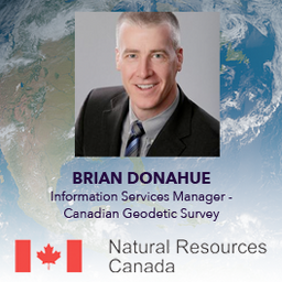
2:45 PM
2:45 PM
- Canadian Geodetic Survey – Supporting Accurate Geospatial Positioning in Canada
- 2:45 PM EDT - 3:15 PM EDT | 30 minutes
- The Canadian Geodetic Survey (CGS) of Natural Resources Canada (NRCan) is responsible for defining, maintaining, and providing access to the Can...
- Talk
-
10:45 AM
10:45 AM
- A Tale of Two Cities - Quality cartographic output for your data with Adobe Illustrator and MAPublisher
- 10:45 AM EDT - 11:15 AM EDT | 30 minutes
- In this presentation by Avenza Systems, we will be showcasing how high quality cartographic outputs after your data analysis can actually be ach...
- Talk
-

12:10 PM
12:10 PM
- Lunch Break, Awards and Announcements
- 12:10 PM EDT - 12:30 PM EDT | 20 minutes
-

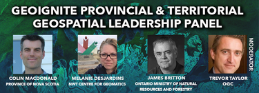
2:45 PM
2:45 PM
- Canada’s Provincial & Territorial Geospatial Leadership Panel
- 2:45 PM EDT - 3:45 PM EDT | 1 hour
- Join GeoIgnite for this inaugural panel of provincial and territorial geospatial and location technology leaders.We will be discussing i...
- Panel