Javed Iqbal
Sessions in which Javed Iqbal attends
الأربعاء 2 مارس, 2022

Join Jonathan Murphy and John Roos as they kick off the start of Day 2 Winter Geo:GeoIgnite 2022 and share some information on the upcoming workshop week.


الجمعة 4 مارس, 2022

In this short technical demonstration, I’ll explore some of the ways that Planetscope’s new 8-band capabilities can be used to both detect and monitor invasive plant species, such as Watermoss-Salvinia, within water bodies. We’ll focus on the role that the 4 new spectral bands (Coastal Blue (433-453nm) , Yellow (600-620nm), Green-II (547-583nm) and Red-edge (697-713nm)) can have in this use case. I’ll compare how some spectral indices unlocked via 8-band data compare to previous 4-band, RG...

الإثنين 7 مارس, 2022

The world is dynamically changing and so are businesses. By some estimates, 20% of new businesses close within one year of opening. In 2020,

الثّلاثاء 8 مارس, 2022

Maxar’s WeatherDesk is a mature product platform that has continually evolved to satisfy changing customer requirements. It sets the standard for reliable and accurate weather forecasting through sound attention to science, an intense focus on customer service including 24/7 meteorological and operational support, and optimally solving customer problems. WeatherDesk products elegantly translate weather data into insights and actionable intelligen...


This workshop will use open tools and standards to create STAC compliant data for a Canadian Federal Dataset. The workshop will focus on the nuances of working on Canadian Data in a Cloud environment. It will further demonstrate modern geospatial data science tools to create a SpatioTemporal Asset Catalogue. Sparkgeo will also demonstrate use in leading desktop and cloud mapping software.


الأربعاء 9 مارس, 2022

The Topobathymetric Lidar Solutions & Applications Workshop presented by NV5 Geospatial is designed to provide a comprehensive overview of topobathymetric lidar in a relaxed, collaborative environment to allow discussion and answer any questions. This interactive, virtual event will review our latest sensor technology, present typical project planning and execution, and provide processing insights to successfully completing and delivering ...

Join us in this training to learn about some of the latest and greatest features in ERDAS IMAGINE! With the exponentially increasing amount of data being collected in the world today, customized repeatable, batchable workflows are needed to extract as much valuable information from raw data as possible. The Spatial Modeler is the key to setting up these types of workflows. The creation of spatial models and the use of AI, machine learning and deep learning allow mo...

الخميس 10 مارس, 2022

Taking urgent action to combat climate change and its impacts" is a crucial goal set forward under Goal 13 – Climate Action as part of the United Nations Sustainable Development Goals (SDGs).Climate action requires global efforts related to climate change mitigation – reducing the flow of heat-trapping greenhouse gases into the atmosphere, or enhancing the "sinks" that accu...


الجمعة 11 مارس, 2022

At a time of rising climate change impacts, there is a vital and growing need to prepare for, respond to, and recover from natural disasters. But there is a critical communication gap between authorities, citizens, and communities. Drawing on the ongoing results of our massive multi-year climate change research project, and with assistance from hundreds of students, citizens, academics, NGOs, government officials, and industry partners, Deploy Solutions has identif...

الإثنين 13 مايو, 2024

This workshop will introduce you to the ENVI Ecosystem, a powerful suite of tools for processing and analysing remotely sensed data. We'll focus on its applications for using hyperspectral, multispectral, and SAR data to monitor climate change indicators like:- Vegetation Health- Deglaciation- Greenhouse Gas Emissions- Land Cover Change- Shoreline ErosionWe will also demonstrate how to leverage ENVI’s AI-powered Deep Learning tools to automate the extraction of a...


CATALYST (PCI Geomatics) has played a critical role in supporting the Government of Canada, Academic and Commercial organizations to meet their objectives processing satellite optical, SAR and aerial data using advanced science and automated workflows. New design patterns make it possible to implement the same great technology in new, innovative ways. What we will cover: In this workshop we will demonstrate how to scale processing using various approaches including:Bu...


Location:Play Food & Wine1 York St, Ottawa, ON K1N 5S7https://www.playfood.ca/
الثّلاثاء 14 مايو, 2024
Mini Continental BreakfastGeoIgnite is delighted to offer a selection of chilled fruit juices, freshly baked croissants, muffins, and breakfast pastries, served with butter and preserves. Guests can also enjoy fruit cocktails and yogurt. Available beverages include coffee, tea, and decaffeinated coffee.

Connecting the knowledge economy to the emerging relationship economy in a geospatial context. This talk will emphasize the growing importance of social skills and human connectivity in harnessing the power of data and technology. His talk, titled "Human Interoperability: Enhancing Geospatial Effectiveness in the Relationship Economy," explores the notion of valuing existing resources and optimizing the use of data and technology, particularly in the geospatial sector. As the Executive Office...

GeoIgnite is thrilled to present its keynote session, "Canada's Geospatial Leadership Panel," a gathering of some of Canada's most influential figures in the field of geospatial technology in Canada. Panelist: Melanie Desjardins, Director of the NWT Centre for Geomatics, showcases the application of geospatial technology in public sector management and natural resource governance. Her leadership in geomatics plays a significant role in shaping policies and strategies that utilize ...


In today's rapidly advancing technological environment, the imperative for robust digital governance has never been more critical. The rapid increase of digital technologies and data has underscored an necessity for standardized governance frameworks that not only bolster security and trust but also ensure innovation and efficiency across diverse global systems. This presentation will delve into the paramount importance of establishing and adhering to consensus-based standards in ...

Following the definition set out in the United Kingdom by Digital Built Britain, we understand a digital twin to be “...a realistic digital representation of assets, processes or systems in the built or natural environment…that adds social and economic value by augmenting the decision-making process.” Further, this digital representation has the capacity to exchange real time information with its physical twin and to use that information to learn, predict, or enact a possible response to a gi...

Day 1 Lunch Buffet MenuIndulge in a vibrant selection at our buffet, featuring a house blend of baby spinach, kale, and mesclun greens tossed with feta cheese, a custom blend of seeds, dried cranberries, and golden raisins. Savor the exotic flavors of curried couscous with raisins, freshly made...

The global OGC community continues to accelerate innovation, based on practical real world demonstrations of the art of possible for connecting and sharing data and information related to climate resiliency for disasters, climate monitoring for terrestrial and marine environments and more. This talk will provide a brief overview of the latest work, with a focus on "what is next?".


In the upcoming Canada's National Geospatial Conference, we are delighted to host a special plenary session, "Mapping the Future: Honoring Geoff Zeiss and His Transformative Work in Geospatial Technology," on May 14th in Ottawa. This session is dedicated to celebrating the remarkable contributions of Geoff Zeiss to the fields of mapping, utilities, and Geographic Information Systems (GIS).Geoff Zeiss, renowned for his insightful blog...


After a description of the Canadian Space Agency (CSA)'s mandate and mission, an overview of the different sectors in the Canadian Space Agency that touch on geomatics, is given. Different roles are described and the relationships with external entities as part of these roles. Examples of profiles of people at CSA are given.
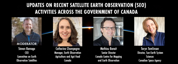
GeoIgnite is excited to present an all star panel discussion on earth observation in Canada. This panel brings together a trifecta of esteemed experts from various Canadian government agencies, with Steven Ramage, CEO of the Committee on Earth Observation Satellites (CEOS), serving as the moderator.Moderator: Steven Ramage, in his role as CEO of CEOS, brings a wealth of knowledge and experience in satellite earth observation. His expertise in coordinating international satellite earth ...


الأربعاء 15 مايو, 2024

Mini Continental BreakfastGeoIgnite is delighted to offer a selection of chilled fruit juices, freshly baked croissants, muffins, and breakfast pastries, served with butter and preserves. Guests can also enjoy fruit cocktails and yogurt. Available beverages include coffee, tea, and decaffeinated coffee.

GeoIgnite is excited to present a high-profile panel discussion, "Navigating New Frontiers: The Role of Geospatial AI in Shaping Our World." This session brings together three influential leaders in the field: Bilyana Anicic, President of Aurora Consulting, Jon Lipinski, Co-Founder and President of Ecopia Tech; Abe Tarapani, CEO of Atlas AI; and Will Cadell, CEO of Sparkgeo.Bilyana Anicic, President of Aurora Consulting and the architect of the Federal Geosp...


Remote sensing and spatial analytics have substantial utility to support riverine and floodplain assessment and monitoring at extents not feasible with traditional field surveys. This presentation will provide an overview of relevant technologies such as topobathymetric lidar, sonar, and multiple imagery types, as well as processes for integrating and analyzing these data. Broad-scale, objective, and reproducible analytics allow for geographic and temporal comparison across entire...


In an increasingly complex and rapidly evolving geospatial landscape, the demand for skilled professionals who can deliver tailored solutions is at an all-time high. Recognizing this need, GoGeomatics Canada, the Sault Ste. Marie Innovation Centre (SSMIC), and OnPar have joined forces to provide comprehensive staff augmentation services that cater to both the private and public sectors.This presentation at GeoIgnite 2024 will detail ...


Climate change is becoming an increasing threat to Species at Risk in Atlantic Canada. Both direct and indirect impacts of climate change are affecting critical habitat, especially in coastal ecosystems. Monitoring species occurrences and their habitat over time and space is essential to effective conservation initiatives and mitigation efforts. The Atlantic Canada Conservation Data Centre (AC CDC) expertise and data represent the single most comprehensive and current source of information ab...


Simplify your AI infrastructure and reduce your interoperability headaches with TileDB, the adaptive database for geospatial AI.The need for geospatial insights with AI requires the management and ETL of legacy geospatial data lakes. Learn how TileDB can model all data as n-dimensional arrays as it sees no data as unstructured. TileDB is multi-modal and supports rasters, point clouds and geometries with a single API.We will explain that TileDB is ideal for Generative AI with geo...

Within its highly dynamic environment, Geospatial Leaders need to integrate knowledge, knowhow, and leadership skills to promote and fully enable this domain while communicating their value proposition to decision makers. This talk will introduce a Framework for leadership development to assist Geospatial Leaders to optimize their success as leaders a...


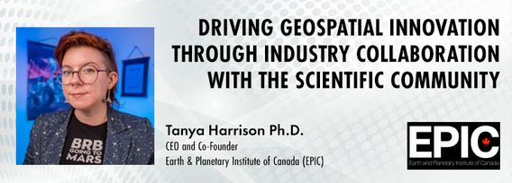
The Earth observation (EO) sector has struggled to break outside its own space echo chamber to have its full potential realised for both social and economic benefit. Can better collaboration between industry and the scientific community help to unlock this potential and drive geospatial innovation? Dr. Tanya Harrison, Co-Founder and CEO of the Earth and Planetary Institute of Canada (EPIC), will highlight examples of such collaborations that have led to breakthroughs that enhanced both indust...

Day 2 Day Lunch Buffet MenuOn the final day of GeoIgnite, enjoy an exquisite lunch buffet featuring artisanal garlic focaccia and a classic Caesar salad, with croutons and bacon bits served on the side. Relish a medley of olives and marinated mushrooms. Savor lightly breaded chicken breast glazed in a tomato and basil sauce, topped with ...

Embark on a dynamic exploration of governance fundamentals at the Mastering Governance: Building Strong Foundations session. In the current complex and rapidly evolving business environment, implementing effective governance practices are foundational to guiding organizations toward sustainable growth and resilience.Effective ...

Climate change presents an array of unprecedented challenges to global resilience and sustainability. As the urgency to address these challenges increases, the role of geomatics as a cornerstone technology for enabling climate resilience becomes ever more significant. This panel discussion, moderated by Tanya Harrison of the Earth & Planetary Institute of Canada, will explore the transformative potential of geomatics in bolstering climate resilience.


Canada is big, really big! Mapping the whole country took us over 100 years to complete. Through the years, the techniques used to map Canada's features evolved.For NRCan, the latest innovation is in the operational implementation of Artificial Intelligence tools and approaches, nested in high performance cloud computing capacity, and build via micros-ervices for agile and scalable deployment. This capacity, enables the organization to increase exponentially its capacity to create and ...
