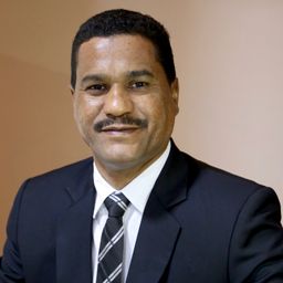
Gafer Edrise
A seasoned and innovative geospatial expert with 15 years of experience spanning 4 countries. My ability to produce excellent spatial data results by utilizing a wide range of geospatial information from multiple sources coupled with strategic planning, coding and administrative skills makes me stand out from the crowd.
I utlize several sources including remote sensing data (satellite imagery, Lidar, mobile mapping system MMS), photogrammetry data from aerial photo (Airborne and UAV/Drones), surveying data and existing maps, as well as hydrological and statistical data.
Throughout my years of experience, I have conceptualized and lead large scale, national-level projects with multiple teams in the areas of energy and oil, roads, agriculture and town planning, drawing on and adding to my collective leadership, trouble-shooting and project management skills, alongside the ability to work with different cultures and under a wide range of circumstances.
Sessions in which Gafer Edrise attends
الثّلاثاء 27 أبريل, 2021
Google Chrome is the preferred browser for this session.Tickets for this workshop must be claimed in advance.Have you ever wanted to learn more about Synthetic Aperture RADAR (SAR) and Electo-Optical (EO) products? Come join this session for an introduction to some of the basic imaging parameters and learn about the different p...
الأربعاء 28 أبريل, 2021
Tickets for this workshop must be claimed in advance.The use of drones, officially referred to as Remotely Piloted Aerial Systems (RPAS), has been forecasted to play a key role in the digitalization and further optimization of a variety of geomatics applications such as in resource aggregates management, landfill management, civil engineering (3D reality capture, virtual surveying), and precision agriculture. To help realize this forecast it is important for ...


