
Darren Llewellyn, P.Eng.
Sessions in which Darren Llewellyn, P.Eng. attends
miércoles 27 marzo, 2024

The United States’ National Geodetic Survey (NGS) plans to modernize their National Spatial Reference System (NSRS) in 2025, including adopting a new dynamic geometric reference (the North American Terrestrial Reference Frame of 2022 (NATRF2022)) and a new geoid-based height system (the North American-Pacific Geopotential Datum of 2022 (NAPGD2022)). To ensure continued geospatial referencing compatibility, the Canadian Geodetic Survey (CGS) plans to modernize the Canadian Spatial Reference Sy...

lunes 13 mayo, 2024
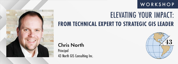
The role of GIS in almost all organizations is evolving from a technical system to an integrative, enterprise-wide capability that provides a unique perspective to solve many business challenges. This half-day workshop is intended to help existing GIS professionals, and those new to GIS in a management position, transition from a technical "What and How" focus on GIS technology to a strategic, value-oriented "Who and Why" mindset around what a GIS can contribute to the organization. The works...


The intent of this workshop is two-fold. First, to provide an introduction to an Open-Source based stack. Second, to provide insights on the use of Open GIS standard formats to power an organization's geospatial applications.To cover the first intent, we will look into the following components:QGIS: The Swiss Army knife for geospatial enthusia...


martes 14 mayo, 2024

Following the definition set out in the United Kingdom by Digital Built Britain, we understand a digital twin to be “...a realistic digital representation of assets, processes or systems in the built or natural environment…that adds social and economic value by augmenting the decision-making process.” Further, this digital representation has the capacity to exchange real time information with its physical twin and to use that information to learn, predict, or enact a possible response to a gi...


This presentation will explore how Sault Ste. Marie leveraged two decades of Geographic Information Systems (GIS) to craft and maintain its cutting-edge Digital Twin. Exploring the innovative applications of Sault Ste. Marie’s GIS digital twin model, which offers real-time insights allowing for collaboration and more effective decision making, this presentation showcases the transformative potential of GIS enabled digital twins. We will demonstrate how this comprehensive digital r...


In the upcoming Canada's National Geospatial Conference, we are delighted to host a special plenary session, "Mapping the Future: Honoring Geoff Zeiss and His Transformative Work in Geospatial Technology," on May 14th in Ottawa. This session is dedicated to celebrating the remarkable contributions of Geoff Zeiss to the fields of mapping, utilities, and Geographic Information Systems (GIS).Geoff Zeiss, renowned for his insightful blog...


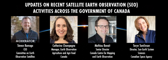
GeoIgnite is excited to present an all star panel discussion on earth observation in Canada. This panel brings together a trifecta of esteemed experts from various Canadian government agencies, with Steven Ramage, CEO of the Committee on Earth Observation Satellites (CEOS), serving as the moderator.Moderator: Steven Ramage, in his role as CEO of CEOS, brings a wealth of knowledge and experience in satellite earth observation. His expertise in coordinating international satellite earth ...


Get ready to mix, mingle, and enjoy an evening of delightful tastes and entertainment at the GeoIgnite Conference Social.Your conference registration includes a delectable assortment of culinary offerings prepared by the head chef of the OEC. Indulge in a variety of hot canapés, including Vegetable Spring Rolls, Spanakopita, Chicken Skewer and Lamb Spiedini. Our cold selection features Cucumber with Dill Cream Cheese and Shrimps, Bri...
miércoles 15 mayo, 2024

As evidenced by the 2023 fire season, we are experiencing unprecedented fire management challenges in Canada. Innovative fire monitoring solutions can help support wildfire managers as they limit the negative impacts of wildland fires while also prioritize the positive benefits in Canada’s forested ecosystems. Opportunities for advancing fire monitoring mirror a broader paradigm shift in the field of Earth observations towards open data, large-scale analyses, and collaborative development. In...


The domains of BIM and GIS have historically been separate areas of expertise and been considered distinct and separate domains. However, the need for geospatial technologies to integrate with Building Information Modeling (BIM) design applications and the need for BIM geometry and data to be applied in Geographic Information Systems (GIS) is becoming more prevalent. In the rapidly evolving period of urban development, BIM and GIS emerge as pivotal technology tools shaping the future of...


GeoIgnite is excited to present a high-profile panel discussion, "Navigating New Frontiers: The Role of Geospatial AI in Shaping Our World." This session brings together three influential leaders in the field: Bilyana Anicic, President of Aurora Consulting, Jon Lipinski, Co-Founder and President of Ecopia Tech; Abe Tarapani, CEO of Atlas AI; and Will Cadell, CEO of Sparkgeo.Bilyana Anicic, President of Aurora Consulting and the architect of the Federal Geosp...


The Department of National Defence, as steward of a real property (RP) portfolio that includes tens of thousands of buildings and supporting infrastructure, is seeking to manage its Real Property (RP) assets more effectively by modernizing and improving its digital capability. In this effort, interoperability between BIM and GIS through open data standards is crucial to enable the Integrated Digital Built Environment. BIM allows representation of detailed information regarding building elemen...


Climate change is becoming an increasing threat to Species at Risk in Atlantic Canada. Both direct and indirect impacts of climate change are affecting critical habitat, especially in coastal ecosystems. Monitoring species occurrences and their habitat over time and space is essential to effective conservation initiatives and mitigation efforts. The Atlantic Canada Conservation Data Centre (AC CDC) expertise and data represent the single most comprehensive and current source of information ab...


The Applied Geomatics Research Group, a spinoff of COGS at NSCC in 2000 has been conducting applied research using lidar since it’s inception. Originally by contracting lidar providers to conduct surveys in the Maritimes for flood hazard mapping, then in the 2005 operating their our topographic lidar, the Optech ALTM 3100, then moving into the coastal environment with the Leica Chiroptera 4X topo-bathymetric lidar, and most recently moving to the relatively low cost drones for topo-lidar mapp...


GeoIgnite is proud to present a vital panel discussion titled "Bridging Worlds: Integrating BIM and GIS for a Digital Future in Built Asset Management," featuring distinguished panelists Susan Keenliside, Deputy Director at the House of Commons of Canada, and John Hale, Vice-President of buildingSMART Canada and BIM lead at the Department of National Defence. The session will be moderated by Trevor Taylor of the Open Geospatial Consortium (OGC).


Remotely Piloted Aircraft Systems (RPAS), or drones, are becoming more common in the construction industry as a key tool to complete complex building and infrastructure projects. As technology improves, the barriers to adoption are reduced, creating a huge opportunity for the industry to improve the construction process and support the ongoing digital transformation. Drones boost productivity by enabling construction teams to rapidly and easily survey job sites, track progress, and spot poten...


buildingSMART and the Open Geospatial Consortium have recently published the results of their collaborative effort aimed at developing a joint roadmap toward seamless information continuity between BIM and GIS domains. This session will provide insights regarding this collaborative effort and the joint roadmap between both organizations, which aims to enhance alignment between the two industry bodies on this critical subject. Discover how this roadmap has been crafted to capitalize on global ...
