
Wendy Creed
Sessions in which Wendy Creed attends
miércoles 22 julio, 2020

Opening Remarks by GeoIgnite founder Jonathan MurphyKeynote address: Geospatial Opportunities in COVID TimesGeospatial capacity has been helpful in providing answers to Canadians during a time where nothing seems normal anymore. At the forefront of tracking, reporting and managing the response to the COVID crisis are geospatial tools, data and leadership. Natural Resources Canada’s Canada Centre for Mapping and Earth Observation supported the Government of Canada’s response b...


Building on the panel discussion at GeoIgnite 2019, David Acco will discuss the potential of geospatial data and analytics to advance issues critical to Indigenous communities across Canada, from exerting sovereignty over territory, to environmental protection and climate change adaptation, to natural resources development. Mr. Acco will further outline how his firm, Acosys Consulting Services Inc., has developed an approach to marrying Indigenous Traditional Knowledge (ITK) and geospatial...
jueves 23 julio, 2020

A closer look at some of the lidar-derived innovations for enhanced forestry management solutions and topobathymetric flood mitigation from Quantum Spatial Canada. Presented by Sven Cowan, Dr. Andrew Brenner, and Colin Cooper. Quantum Spatial, Inc., an NV5 company, is one of North America's largest geospatial services firms, providing insights to organizations that need geospatial intelligence to mitigate risk, plan for growth, better manage resources and advance scientific ...

Agriculture Canada’s COVID-19 response with location data & technology helping drive Objectives and Key Results (OKR’s) on the Enterprise GIS Roadmap This talk is designed to provide insights and guidelines for managing and directing Geospatial programs and uses the COVID-19 response (Maps Apps and Data) and digital transformation as the means to achieve the Objectives and Key Results of the Geomatics program.At AAFC the strategic initiatives of our data driven...
viernes 24 julio, 2020
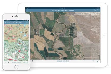
In this presentation, Avenza’s Nick Burchell will provide a series of case studies on how maps created with the Avenza suite of tools are being used to solve tangible needs in the industries where we serve. Learn how our customers are creating high-quality, spatially aware cartographic products through MAPublisher and Geographic Imager in Adobe CC, and how they are using them for critical work in conjunction with the Avenza Maps app. We will also review some of the exciting new initiatives...