
Richard Estephan
Sessions in which Richard Estephan attends
lunes 12 mayo, 2025

This open forum invites all attendees to engage in discussions on Canada’s path toward greater self-reliance in the geospatial sector, particularly in light of emerging trade conflicts, including the recent U.S. tariffs, and evolving global geopolitical shifts. The forum will explore strategies to strengthen Canada’s technological capabilities and reduce reliance on external sources, with a focus on fostering innovation, security, and growth.


Canada's Centre for Mapping and Earth Observation (CCMEO) and GoGeomatics Canada have invited Canadian students to use GEO.ca, the definitive source for Canada's open geospatial information, to develop innovative solutions for a specific challenge scenario in the months leading up to GeoIgnite.The results of the 2025 Hackathon will be announced at GeoIgnite. The presentation will include an overview of GEO.ca and the purpose and challenge of the Hackathon, followed by presentations from t...

Join us for a thought-provoking lunchtime discussion where we explore the evolving landscape of Canada’s geospatial industry while enjoying a delicious meal.The concept of Two Solitudes has long symbolized the cultural and linguistic divide between English and French Canada, but how does this idea still resonate within our geospatial ecosystem to...


Join us for the OGC Canada Forum! We’ll dive into key topics like the Canadian Geospatial Data Infrastructure (CGDI) and how Building Information Modeling (BIM) integrates with Geographic Information Systems (GIS). This event gathers experts from industry, academia, Indigenous organizations, and government to explore these technologies' impact on Canada’s built environment. We'll also cover how OGC standards boost interoperability and innovation. All Canadian organ...


📅 Date: Monday, May 12, 2025📍 Location: Rainbow Bistro, 76 Murray Street, ByWard Market, Ottawa⏰ Time: Networking at 6:30 PM | Panel begins at 7:00 PM | Live music to follow🍽 Details: Cash bar and hors d’oeuvres provided Event OverviewJoin us for an evening of high-level discussion, networking, and live music in the heart of Ottawa’s historic By...


martes 13 mayo, 2025

Mini Continental BreakfastGeoIgnite is delighted to offer a selection of chilled fruit juices, freshly baked croissants, muffins, and breakfast pastries, served with butter and preserves. Guests can also enjoy fruit cocktails and yogurt. Available beverages include coffee, tea, and decaffeinated coffee.


For decades, Canada’s geospatial ecosystem has thrived on deep integration with the U.S., benefiting from shared technology, markets, and collaboration. But today, shifting geopolitical and economic realities—trade conflicts, supply chain vulnerabilities, and data sovereignty concerns—are forcing us to rethink this reliance. The question is no longer whether we should adapt, but how.

Dr. Nadine Alameh, the inaugural Executive Director of the Taylor Geospatial Institute, has been leading an ambitious effort to accelerate geospatial research for tackling today’s biggest challenges—climate, disasters, health, and national security. In this session, she will reflect on what it takes to build a truly impactful geospatial ecosystem, challenge assumptions about the roles of national mapping agencies, academia, and nonprofi...

The Canadian Hydrographic Service (CHS) is Canada's agency for charting Canadian waters. Canada has the longest coastline of any country in the world, with more than a third of its territory under water. As a maritime nation, global maritime transport traffic is significant. Hydrography supports safe navigation and shipping through the production of nautical charts and other publications including water levels. With opportunities provided by emerging technologies and the move to e-navig...


In 2006, British mathematician Clive Humby declared that data was the new oil. Soon after there was a significant rush around the world to embrace a data revolution to try and improve humanity’s social, economic and environmental well being. Twenty-years later, the hard work of data continues. Like Canadian oil and gas, it is for the most part – a landlocked asset; unable to push us to the next levels of productivity and innovation. This keynote looks at ...

Artificial Intelligence is transforming how we interpret and act on information—but what does that mean for the geospatial world? As AI models generate synthetic maps, infer locations, and automate analysis, geospatial professionals face a critical moment: will we shape the future, or be shaped by it?In this session, the CEO of the Open Geospatial Consortium (OGC) will explore the complex relationship between AI and geospatial systems—from the risks of black-box models and data halluci...

Top technical performers are often promoted into leadership roles, yet many struggle. In AI-driven, data-intensive industries, expertise alone is not enough—leaders must also navigate complexity, inspire teams, and drive execution. Without these skills, organizations face decision paralysis, disengaged teams, and stalled innovation.Senior leaders know that competency is crucial—technical excellence is the foundation of succes...


At GeoIgnite 2025, Alexander will explore how Canada's geospatial community is uniquely positioned to lead in developing solutions to environmental challenges in a rapidly changing geopolitical landscape. Drawing on compelling case studies from around the globe, including successful Dutch-Canadian collaborations, he will demonstrate how geospatial technologies are becoming indispensable tools for environmental monitoring, climate resilience planning, and sustainable...

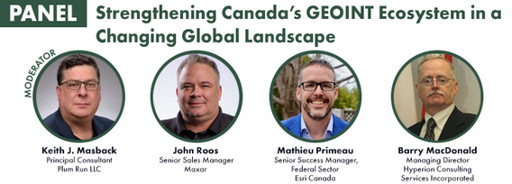
Keith J. Masback is one of the most respected voices in the field of geospatial intelligence (GEOINT), with over three decades of leadership spanning the U.S. government, military, and private sector. His deep expertise in remote sensing, intelligence, and national security has positioned him at the forefront of how geospatial data is used for strategic decision-making.As the former CEO of the United States Geospatial Intelligence Foundation (USGIF) and a senior leader at the National ...


A seasoned leader in geomatics and Earth Observation with two decades of experience in the federal government, Eric Loubier has vast expertise in developing and implementing national geomatics and Earth observation strategies. In his talk, Eric will explore the integration of AI with Earth observation, and how this powerful combination is transforming Canada’s approach to addressing critical national issues like climate change, natural resource management, urban planning, and disaster response.


GET YOUR TICKETMORE PURCHASING OPTIONSJoin us for an exclusive Networking Party at the Canada Science & Technology Museum as part of the 2025 buildingSMART Canada National...
miércoles 14 mayo, 2025

Mini Continental BreakfastGeoIgnite is delighted to offer a selection of chilled fruit juices, freshly baked croissants, muffins, and breakfast pastries, served with butter and preserves. Guests can also enjoy fruit cocktails and yogurt. Available beverages include coffee, tea, and decaffeinated coffee.

As the geopolitical landscape shifts and a new global space economy emerges, Canada must navigate complex international dynamics and seize opportunities in all facets of the space ecosystem. In this talk, we will explore how space can be part of the solution to geopolitical and national challenges—and what Canada must do to stay ahead in a rapidly evolving global landscape.


The successful implementation of the S-100 suite hinges on various factors, with final product specification and comprehensive testing of route monitoring layers being paramount. Canada is proposing an international designated area for these tests, underscoring its commitment to the S-100 suite's success and global maritime safety. Canada has selected the St-Lawrence River in Québec as the S-100 sea trial area for 2025. The trial aims to evaluate the S-100 system's ability to ingest and displ...


Unlocking the Power of EO and AI through Collaboration and PartnershipsThis panel will explore the transformative power of Earth Observations (EO) and Artificial Intelligence (AI), emphasizing the critical role of collaboration and partnerships in unlocking the full potential of these technologies. As global challenges continue to evolve, th...


Spatial data and related technologies have long powered the disciplines of geomatics (and its many names likes geospatial, hydrospatial) and buiilding information management. These disciplines have enabled people to better understand the natural world, the built infrastructure we place upon it, and, increasingly, the relationships between the two. The various goods and services provided by these different "spatial" communities has been global in nature and have provided eco...


The convergence of generative artificial intelligence and geospatial technology is transforming how we validate and ensure the quality of location-based data. This talk explores how AWS is enabling new approaches to geospatial data validation through the power of generative AI, which helps public and private sector organizations achieve their sustainability missions.As we operate in a world with more earth observation data being generated everyday, the planet is imaged daily and, with ...


Digital Twins hold enormous potential for the buildings and infrastructure sectors, but their implementation faces key challenges. What is a Digital Twin? The industry lacks a clear consensus, leading to misinformation and confusion. While Digital Twins can scale, not every project requires every possible capability—so how do we manage this effectively? More importantly, the industry is not ready—foundational work in data standards, interoperability, and governance is still needed.In r...


The Open Building Population Layer for Canada has emerged as a transformative resource in the geospatial community, providing unprecedented access to population estimates at the building level across the country. Since its release, the dataset has garnered significant attention, reaching 8,000+ professionals on LinkedIn, and achieving thousands of downloads. This enthusiastic reception underscores its value for applications in urban planning, disaster management, and environmental assessments...


Join us as we wrap up another incredible edition of GeoIgnite with a celebration on the tradeshow floor. We’ll come together for a group photo of all our amazing participants, partners, and friends.This final moment is our way of saying thank you to everyone who helped make GeoIgnite a success — from speakers and sponsors to delegates and volunteers. Let’s end on a high note and capture the spirit of Canada’s national geospatial leadership event, together.