Trevor Taylor, currently accountable for global member success and development at OGC, has over thirty years of experience in the international geospatial community. With a background in Geography, Mr. Taylor has worked on a wide variety of applications such as Marine, Land Information, Disasters Management, Agriculture, Mapping, Forestry and Environment.
Mr. Taylor has substantial global experience in a wide variety of technical, client services, project, business and strategic planning activities. Prior to joining OGC staff, Mr. Taylor was a member representative for a commercial company to OGC, supporting OGC interests at the voting, principal, and strategic member levels, particularly in Asia, South America, India, and Europe.
Sessions auxquelles Trevor Taylor participe
Jeudi 3 Mars, 2022
By some estimates, 80% of response time during a disater is spent procuring and preparing data, leaving 20% of the time learning from data. We can do better. Sponsored by USGS/FGDC, Natural Resource Canada, NASA and supported by CONIDA (Peru) and Amazon Web Services, the goal of the pilot was to develop standards-based services to support rapid decision making through the full life-cycle of disaster management for multiple hazards.
Mardi 7 Novembre, 2023
With climate change comes a massively increased risk to billions of people due to disasters, reduced food and energy security, environmental degradation, and sea level rise to name a few. For example, it is estimated that 200,000,000 people live in low-lying areas of the world considered highly vulnerable.The global OGC community has mobilized to improve how well we connect land, sea, and air Geospatial data and information, improve regional connectivity between various SDIS &nbs...
Join us at the BIM/GIS panel of our conference as we delve into critical subjects shaping the intersection of Building Information Modeling (BIM) and Geographic Information Systems (GIS). Our expert panelists will explore the evolving landscape of BIM and GIS, offering invaluable insights into various aspects of this dynamic field.Agenda:The Importance of Standards and Interoperability...
Mardi 14 Mai, 2024
The global OGC community continues to accelerate innovation, based on practical real world demonstrations of the art of possible for connecting and sharing data and information related to climate resiliency for disasters, climate monitoring for terrestrial and marine environments and more. This talk will provide a brief overview of the latest work, with a focus on "what is next?".
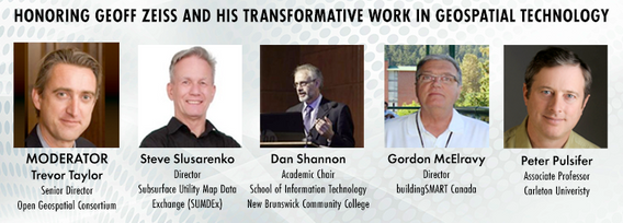
In the upcoming Canada's National Geospatial Conference, we are delighted to host a special plenary session, "Mapping the Future: Honoring Geoff Zeiss and His Transformative Work in Geospatial Technology," on May 14th in Ottawa. This session is dedicated to celebrating the remarkable contributions of Geoff Zeiss to the fields of mapping, utilities, and Geographic Information Systems (GIS).Geoff Zeiss, renowned for his insightful blog...
Mercredi 15 Mai, 2024
GeoIgnite is proud to present a vital panel discussion titled "Bridging Worlds: Integrating BIM and GIS for a Digital Future in Built Asset Management," featuring distinguished panelists Susan Keenliside, Deputy Director at the House of Commons of Canada, and John Hale, Vice-President of buildingSMART Canada and BIM lead at the Department of National Defence. The session will be moderated by Trevor Taylor of the Open Geospatial Consortium (OGC).
Sessions auxquelles Trevor Taylor assiste
Mercredi 21 Avril, 2021
Au cours de la dernière année, Minerva Intelligence, une entreprise d'IA cognitive basée à Vancouver, a remporté deux contrats avec Ressources naturelles Canada pour concevoir des schémas au niveau national: le National Flood Hazard Data Layer (NFHDL) et le National Hydro Network V2 (NHNv2 ). Vous vous demandez peut-être pourquoi une entreprise d'IA conçoit et construit ces structures de base de données importantes. Le système d'IA cognitive de Minerva utilise des données sémantiquement in...
Titre: Faire progresser l'observation spatiale au Canada: Le Panel géospatial des directeurs généraux de GeoIgnite 2021, dans le cadre de la Conférence géospatiale nationale du Canada. Titre: Faire progresser l'observation spatiale au Canada Il s'agit d'un panel incontournable pour quiconque souhaite connaître la direction que prend le leadership géospatial du gouvernement fédéral du Canada. Joignez-vous à nos pané...
Jeudi 22 Avril, 2021
Rejoignez-nous le 22 avril pour une discussion au coin du feu avec le Dr Steve Liang, fondateur et directeur technique de SensorUp. Professeur et titulaire de la chaire de recherche Rogers IoT à l’Université de Calgary et Dr Nadine Alameh, chef de la direction (PDG) de l’OGC.L'objectif de Steve est de perturber les silos de l'Internet des objets en créant, en utilisant et en mettant en œuvre des normes et des produits ouverts et interopérables pour les communications appa...
Vendredi 23 Avril, 2021
L'industrie géospatiale mondiale est estimée à 500 milliards de dollars américains et a un impact encore plus significatif sur la société, avec des avantages économiques dérivés estimés à être multiples. Ces avantages, cependant, ne sont toujours pas pleinement compris par les principales parties prenantes et les décideurs politiques, ce qui entrave en fin de compte l'adoption mondiale des informations géospatiales. Avec des décennies d'efforts d'infrastructure nationale de données spatial...
oignez-vous à GeoIgnite pour ce premier panel de chefs de file provinciaux et territoriaux de la géospatiale et des technologies de localisation. Nous discuterons des problèmes entourant: Quelles sont les principales priorités et défis à travers les juridictions?Quels types d'outils géospatiaux utilisons-nous pour surveiller et répondre à des défis clés tels que les interventions d'urgence?Comment les juridictions harmonisent-elle...


