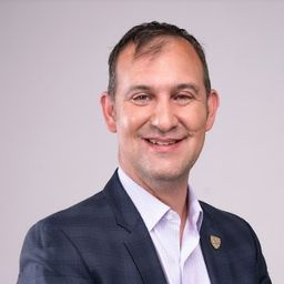
Peter Srajer is the Chief Scientist at Prostar Geocorp, charged with advancing geospatial technology solutions. He has over 20 years of experience in research, development, and implementation of advanced geospatial technologies in a wide variety of fields and challenging locations. Peter believes the use of geospatial technology is critical for operational safety and in striving for the most efficient and cost-effective solutions for stakeholders. Peter holds a Masters in Geomatics Engineering from the University of Calgary, Canada as well as being a licensed Land Surveyor and Professional Engineer.
Sessions auxquelles Peter Srajer participe
Lundi 6 Novembre, 2023
Step into the exciting realm of the inaugural GoGeomatics Expo in Calgary, a historic event that is set to make waves in Canada's geospatial sector. This compelling panel discussion will delve into the groundbreaking significance of this first-of-its-kind expo, exploring why it is a game-changer for both the public and private sectors, and how it charts a new course for the geospatial industry in Canada. This panel discussion takes place after the expo reception buffet. Participants must b...
Mardi 7 Novembre, 2023
SUMMARYWith the increasing focus on damage prevention, public safety concerns, and environmental damage due to underground utility strikes, it has become more critical to accurately locate, store, and be able to visualize subsurface utilities. We show several key technical and business details when implementing a subsurface mapping system from data collection to the use of machine learning for 3D modelling and visualization and give real-world examples and use cases of the different le...
Mercredi 8 Novembre, 2023
This panel will delve into some Geoff Zeiss's favorite topics:Example - Colorado DOT, PennDOT. Not an explicit requirement but required for permitting in their RoW’s – effectively a regulatory standard. Metrolink Regulation1: Business Case for SUE DataASCE – Not a regulatory requirement but a recommendation.Regulate on Backend – Permitting Process requirement for ASCE Benefits of Accurate Data2: Standards
As part of the annual Canadian Expo program, GoGeomatics will be looking to recognize and award individuals and companies that have shown top-level leadership, innovation and forward thinking in the geomatics field. We will establish several categories of awards. The first set for activities at the Expo this year and the second set for next year allowing the community to participate by nominating awardees to be considered.Awards Presented at this year's Expo:Geo...
Mardi 25 Juin, 2024
The applications of GeoAI are as wide and diverse as our imaginations. Many applications like remote sensing, image classification and object detection using computer vision, improve visual clarity and allow higher zoom levels using super-resolution networks, extract geospatial information from unstructured data using natural language processing, deep learning application for large 3D geospatial datasets etc. and have shown positive trends in GeoAI.With the increasing focus on damage p...
Mardi 29 Octobre, 2024
How exactly does artificial intelligence work and what can you use it for in the geomatics domain? Using real-life examples from our projects, they demonstrate how you can use AI to gain new insights and increase efficiency by automating your data processing workflows.We explore how GeoAI is fusing spatial data science and Geomatics technology to help automate the extraction, classification, and analysis of all types of spatial or non-spatial data. Learn how GeoAI can detect clusters, ...
The integration of AI in infrastructure modeling has the potential to revolutionize decision-making processes by providing accurate predictions, identifying vulnerabilities, and optimizing resource utilization.The increasing complexity of modern infrastructure systems, coupled with growing demands on utilities, has necessitated the adoption of advanced analytical techniques. This panel discussion brings together ideas from acad...
Mercredi 30 Octobre, 2024
This panel will explore how to effectively identify the standard and quality level under which Subsurface Utility Engineering (SUE) data was collected, following established guidelines such as the ASCE 38-22 Standard. A key focus will be on how this data can be repurposed for future projects while ensuring that liability does not fall back on the original professional who signed off on the data. Panelists will also discuss t...
With the increasing focus on damage prevention, public safety concerns, and environmental damage due to underground utility strikes, it has become more critical to accuracy locate, store and be able to visualize subsurface utilities. Several key technical details are discussed when implementing a subsurface mapping system from data collection to the use of machine learning for 3D modelling and visualization. The ability to make safe and effective decisions for i...
Sessions auxquelles Peter Srajer assiste
Mercredi 21 Avril, 2021
Le Canada est le chef de file mondial dans le domaine de l'observation de la Terre par radar spatial à grande échelle grâce au programme RADARSAT, qui soutient de nombreuses utilisations opérationnelles et scientifiques des données radar à synthèse d'ouverture (SAR).MDA, en collaboration avec le gouvernement canadien, a créé une marque et une réputation d'excellence internationalement reconnues en matière de données SAR en temps quasi réel sur de vastes zones pour les applica...
Jeudi 24 Mars, 2022
GIS platforms are typically populated with XYZ coordinates with a point spacing of 1 meter or more. in fact, most traditional land surveying techniques, like GPS, often have a point spacing of 3 meters or more, and that is understandable given the procedure to obtain these points. But have you ever wondered what amount of detail is lost when increasing the point frequency? Well, in this seminar, Otto Ballintijn will demonstrate the impact point frequency has on pipe detail usin...
Reveal is building the world's most advanced and accurate digital twin technology for subsurface infrastructure. We're driving a safer, more efficient and sustainable world by revealing the truth of the underground. Join us for a 30min presentation where we will be showcasing our technology through our flagship project in Wellington, New Zealand.
Vendredi 25 Mars, 2022
An overview of Prostar's "Cloud and Mobile Precision Field Data Collection Solution and the set up of the ProStar "PointMan Plus" application FREE to WorkShop attendees. PointMan is a patented cloud and mobile mapping software application that captures, records, and displays the precise location and the associated metadata of critical surface and subsurface infrastructure, all in "real-time" Workshop includes: -1 FREE annual subscription of...
Lundi 6 Novembre, 2023
This workshop will cover the basics of deep learning:- What is deep learning?- A typical workflow using deep learning technology to identify objects (hands-on)- Issues to be aware of when using deep learning technology.- Options for deep learning tools.You need to bring a wifi equipped laptop, as we will be using a cloud-based virtual machine for you to do the exercises.Location: SAIT -
Mardi 7 Novembre, 2023
Join us for an immersive and interactive workshop led by the founder of Cyanic Automation, Doug Kondor. In this engaging session, you'll delve into the world of project management in the context of land surveying, guided by an industry expert with a passion for innovation.Workshop Highlights:Theory Meets Practice:Doug Kondor goes beyond theory, offering a hands-on journey through the best practices of project management. Learn how to bridge ...
Mercredi 8 Novembre, 2023
As part of the annual Canadian Expo program, GoGeomatics will be looking to recognize and award individuals and companies that have shown top-level leadership, innovation and forward thinking in the geomatics field. We will establish several categories of awards. The first set for activities at the Expo this year and the second set for next year allowing the community to participate by nominating awardees to be considered.Awards Presented at this year's Expo:Geo...
Mardi 26 Mars, 2024
Mardi 25 Juin, 2024
In 2017, representatives of Gopher State One Call (GSOC) reached out to the leadership of Emergency Preparedness Committee of the Minnesota Geospatial Advisory Council (EPC) in hopes of learning what could potentially be done to improve the use of geospatial technology in the underground utility community. From ensuing discussions over the next three years, the Underground Utilities Mapping Project Team (UUMPT) came into existence under the auspices of the EPC in early 2020. Now comprised of ...
In recent years, Canada and the United States have witnessed numerous injuries and fatalities due to accidental contact with underground infrastructure, highlighting the need to enhance current damage prevention practices. This presentation, "Knowing What's Below: Maps Save Lives," authored by Steve Slusarenko, Director of Subsurface Utility Map Data Exchange (SUMDEx), delves into the current damage prevention processes and underscores the importance of creating and exchanging accurate maps.<...
Lundi 28 Octobre, 2024
We are excited to announce that the next Canada Forum will be held during the GoGeomatics Expo in Calgary, from October 28th to 30th. This event will bring together key stakeholders from across Canada’s geospatial sector, including industry leaders, academics, indigenous communities, government representatives, and technologists, to continue vital discussions on advancing geospatial standards, interoperability, and spatial data infrastructure (SDI) in Canada.
Join us at the National Geomatics Networking Reception Enjoy a selection of gourmet hors d'oeuvres, including savoury Moroccan lamb meatballs, smoked pork belly lollipops, and wild mushroom arancini with truffle oil. Vegetarian options like vegetable samosas with mango chutney and goat cheese tartelettes will satisfy all palates. Plus, your ticket includes a drink to enjoy while you connect with industry professionals. Elevate your evening with these delicious bites and great company!<...


