
Shawn DeAdder
Elementy, w których Shawn DeAdder attends
środa 22 lipca, 2020

Opening Remarks by GeoIgnite founder Jonathan MurphyKeynote address: Geospatial Opportunities in COVID TimesGeospatial capacity has been helpful in providing answers to Canadians during a time where nothing seems normal anymore. At the forefront of tracking, reporting and managing the response to the COVID crisis are geospatial tools, data and leadership. Natural Resources Canada’s Canada Centre for Mapping and Earth Observation supported the Government of Canada’s response b...


The U.S. reference system modernization effort will replace the North American Datum of 1983 (NAD83) with a new North American Terrestrial Reference Frame (NATRF2022), creating 1.3 to 1.5 m horizontal coordinate differences at the Canada–U.S. border with respect to Canada’s NAD83(CSRS). Never before have such significant differences existed between our two countries’ reference frames.There are compelling reasons for Canada to follow suit and adopt the NATRF2022 frame as our ...

Presented by: Jake Dickinson & John Roos Abstract: As shrinking polar ice creates new opportunities for resource exploration and shipping routes, the importance for Arctic nations to monitor the ongoing expansion in the Arctic is ever increasing. Additionally, climate change continues to impact people and the environment. High resolution satellite imagery remains one of the most effective means of monitoring inaccessible and de...

Strategic Geospatial for a Complex WorldWhere humans move and landscapes change there is value. That’s geospatial. This talk is about how to think strategically about geospatial technology in an increasingly complex world.In particular, we will focus on canada’s strengths, and how we might inject novel geospatial technology into new markets

GIS users’ numbers are expanding around the world. It is now possible to find a GIS use in every field and to optimize their success. Discover how Business Geografic work throughout all fields to offer a new and modern approach to use Geografic Information Systems. Wheter your need are the one of an expanding business, a wide world telecom company or an official government entity, find out how we can help you vizualise your data and improve your process.

Geospatial and location technologies is present and continues to expand its reach in many sectors. Much of the current digital transformation taking place globally is built upon geospatial foundations. In this open panel discussion, our experts will discuss the latest developments and challenges facing the Canadian and global geospatial sector and what the future holds. Key components to be addressed include how has the global pandemic affected our sector and how may we be impacted in the...


Our next-generation Earth imaging constellation will change everything. We're not just launching more satellites. In 2021, we will deploy WorldView Legion which will provide unprecedented visibility into our changing planet to solve the biggest challenges facing our world today. Grab your favorite beverage and join Maxar for a casual conversation about our next constellation, Legion! Everyone who joins will be entered for a chance to win an IPad!


czwartek 23 lipca, 2020

Title: Growing Canada’s Next Earth Observation (EO) GenerationCanada has a proud history in Earth Observation, supporting a strong export industry driven on EO imagery and geospatial analytics. It is incumbent on all of us to continue Canada’s strong presence in the global EO community and we can only do that with a concerted effort and plan to grow the next generation of leaders. After 51 years of leadership in space and spatial information technology MDA was recen...

A closer look at some of the lidar-derived innovations for enhanced forestry management solutions and topobathymetric flood mitigation from Quantum Spatial Canada. Presented by Sven Cowan, Dr. Andrew Brenner, and Colin Cooper. Quantum Spatial, Inc., an NV5 company, is one of North America's largest geospatial services firms, providing insights to organizations that need geospatial intelligence to mitigate risk, plan for growth, better manage resources and advance scientific ...

A new era of human experience is upon us. The current disruption brought by the COVID-19 crisis has thrust us from a mere “digital transformation” into a new digital reality.The COVID-19 crisis is rapidly reshaping the "what" and "how" of digital transformation agendas. Through leveraging IoT, Big Data, blockchain, AI, location intelligence, etc., organizations are improving their operations and business decisions.We reached a turning point in ...

The GeoIgnite Conference and our sponsors are proud to present the second Diversity Leadership panel. Our inaugural Summit was a great success featuring relevant diversity and inclusion topics, a powerful panel of speakers, and a "full house" of engaged participants.Increasing the diversity, equity, and inclusiveness of the Geomatics community is essential to our mission. There can be no barrier to talent at Geospatial organizations as solving the world’s most intractable proble...


Join space specialists Nick Kellett, CEO of Deploy Solutions and Kevin Jones, VP Product at PCI Geomatics for this informal, fun and insightful event! Nick and Kevin, both big hackathon advocates, will share their recent experiences of working together on exciting challenges, as well as looking at some of the coolest moments in recent space history. The session will be interactive and include a quiz and a prize giveaway, so be sure to join us for a great hour of space chat and socializing!


piątek 24 lipca, 2020

In recognition of the increasing costs and risk due to flooding, the Government of Canada is investing in flood mapping as part of the Government’s commitment to build safer and more resilient communities. Flood maps are critical for the public to understand their flood risks, and the availability of up to date flood hazard maps are key to strengthening the resilience of Canadian communities to overland flooding. Natural Resources Canada (NRCan) has been working in collaboration to advance...

We are living through a transformative time, not least in the space industry. A graph of upcoming satellite launches looks like a hockey stick – soon there will be orders of magnitude leading to more satellites being launched and more downstream data being generated from space than ever before. The question is, what is the most effective means of ensuring that space data brings tangible benefits to business operations and value to end users? In our talk we cover a satellit...

The key elements to take into account a successful implementation of drone survey with a mm accuracy are: Know your camera; Trust your measurement; Control your space; Understand your photogrammetry software. Working out that, we present this nuance including special tags around the surveyed object as the measurement system to get details.A correct implementation of photogrammetry tags with consumer grade measurement devices and consumer grade UAVs and cameras enables very precise a...

Abstract A fundamental shift in the geospatial industry has occurred over recent years. Modern remote sensing technology has been developed at PCI Geomatics and in Canada through advanced research through partnerships with private industry, academia, and government researchers. Ubiquitous access to openly accessible earth observation data, cloud computing infrastructures and international collaboration have created opportunities to increase downstream access to inf...
poniedziałek 6 listopada, 2023

Join us as we open the GoGeomatics Expo with a memorable evening filled with delicious food and great conversation! Elevate your Expo experience and forge valuable connections with fellow attendees, exhibitors, speakers and panelists. Following dinner, there will be a special panel moderated by GoGeomatics founder...
wtorek 7 listopada, 2023

SUMMARYWith the increasing focus on damage prevention, public safety concerns, and environmental damage due to underground utility strikes, it has become more critical to accurately locate, store, and be able to visualize subsurface utilities. We show several key technical and business details when implementing a subsurface mapping system from data collection to the use of machine learning for 3D modelling and visualization and give real-world examples and use cases of the different le...


Join us at the GoGeomatics Expo in Calgary for a concise panel discussion on the present and future of geomatics education. Our panel, comprised of professors and industry experts, will address the following key topics:1. Current State of Geomatics Education:Explore the status of geomatics education in Canada.Understand how educational programs are adapting to ind...


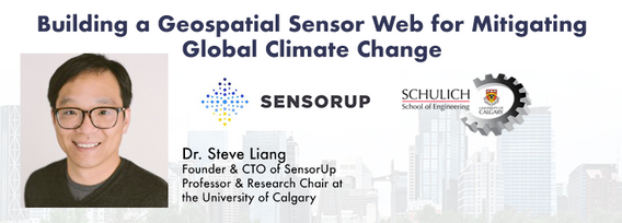
Addressing the escalating levels of methane in the Earth's atmosphere is among the most urgent issues humanity faces. Methane ranks as one of the most potent greenhouse gases (GHGs), trapping over 25 times more heat than carbon dioxide over a 100-year period; thus, significantly reducing methane emissions will make a substantial impact in the fight against climate change.One of the most impactful methods for mitigating methane emissions involves the prompt detection and repair of metha...

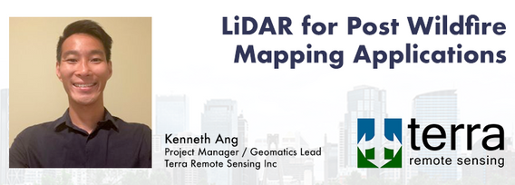
LiDAR continues to be a cornerstone of the mapping industry. Since its inception, the technology has evolved from sole use on manned aircraft to being used on UAVs and mobile mapping platforms. As the LiDAR industry continues to evolve, our panel of experts will discuss what current and future trends impacting this industry. Join our award-winning panelists for an exciting discussion. Bring your questions.


This talk focused on those seeking work in GIS, cartography, remote sensing, programming, and other related geospatial fields.Jonathan Murphy, Managing Director of GoGeomatics Canada and geospatial career coach, will be sharing his valued tips and insight for your job search. He is an expert geomatics professional with close to 20 years of experience. Jon’s career has ranged from the oil fields of Alberta to projects with...

Geomatics is growing technically and economically at a rapid pace. The need for skilled, knowledgeable workers is higher than ever. Some may argue that the technical advancements of the industry reduce the need for skilled workers and will remove the event of human errors. Others will argue that the very technology that is reducing human error can lead to increasing other errors and be a cause of delays on projects if the person operating the technology is not perceptive ...
Learn how newly implemented surface modeling tools employing artificial intelligence reduce the turnaround time of point cloud surface models by 400% while maintaining high-fidelity results around break lines. Faster ground extraction routines for UAV data can be achieved without the need for classification or noise removal. In this presentation, we'll discuss several examples including how a query volume calculation project compared with traditional modeling workflows yielded nearly exact...
