
Marc Curtis
Elementy, w których Marc Curtis attends
wtorek 18 czerwca, 2019

Jonathan Murphy the Founder of GeoIgnite and GoGeomatics welcome participants to the conference
There's never been a more exciting time to be a part of the geospatial profession. From mapping the infrastructure beneath our cities to indoor wayfinding, to plentiful and powerful remote sensing capabilities in air and space which we could hardly have imagined just a few years ago, the opportunities - and the expectations - for geospatial professionals are immense. Technology is evolving at a pace which outstrips the ability of academics, governments, and industries to keep pace. How will w...

Let’s admit it! We live in exciting times with technology, social interactions and business models changing before our eyes: Flying taxis, self-driving cars, commercial Space missions, smart cities, SmallSats and Internet Of Things (IOT) to name just a few innovations! Our kids are growing up in a world of on-demand TV, GPS availability, all around virtual assistants, and mobile devices that pretty much can do anything! Each and every one of these innovations has a location element to i...
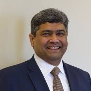
Prashant Shukle is the Director General for the Canada Centre for Mapping and Earth Observation Branch, Earth Sciences Sector, at Natural Resources Canada (NRCan).NRCan has fostered an enabling policy mechanism and provided a conducive framework for geospatial information infrastructure. In today’s digital age when geospatial is becoming more and more ubiquitous, open and inter-disciplinary policies are the key instruments of harnessing the true value of this wonderful technology...
What are the ramifications of the current digital transformation globally and what will it mean for Canada and the globe? Our award winning panel of international and Canadian experts disscuss and take questions from delegates.


Break

Several key trends in the geospatial industry over the last few years have created the conditions needed to truly leverage remote sensing as a technology that has the potential to provide tremendous benefit to civil society. These include changes in data policy, most notably with USGS's decision in 2008 to make all Landsat archives free and open, a policy which led the European Space Agency to also implement free and open access to the Copernicus constellation. The volume of data that is incr...
The UK Government as part of its building information modeling (BIM) initiative has said repeatedly that it expects the big payoff of a digital model will be during operations and maintenance, which typically represents 80% of the cost of a facility. Companies who do design, build, finance, and maintain, or design, build, operate, or PPP projects often employ a full lifecycle BIM + geospatial strategy. For example, Crossrail appears to be the first major project that may be able to provide su...

Cloudy with a chance of data science.Sparkgeo had been building cloud first geospatial applications, from day 1. But that was not the plan. The plan was to make more maps for more people, using the internet.Sitting at the intersection of software development and GIS we see how these two communities can benefit from each other. But, to do so, we will have to step out of our comfort zones.Let me tell you the story of a lowly GIS tech's journey through the technol...

We are entering a new era of positioning, navigation and timing. Global, instantaneous, and easily accessible positioning at better than 10cm is coming, which will provide new ways of doing business and create new businesses in areas such as augmented reality. In recent years global Positioning, Navigation and Timing have been undergoing rapid technological development. New GNSS constellations (Galileo, Beidou) with new signal structures offer increased capabilities, while future posi...
środa 19 czerwca, 2019

John Roos welcomes delegates and introduces the morning Industry tract as MC for GoGeomatics Canada.

As we worked with multiple government organizations this past year, we faced this same question along the way: Should we move our data processes to the cloud? Now as much as we would like to give you a yes or no answer, there are different paths or options you need to explore inside your organization before taking this decision. In this presentation, you will hear about the latest trends and some ways to use the Cloud as a platform for geo data processes. You will also learn different conside...

The Government of Canada purchases on average $22 billion in goods and services each year to help deliver programs and services to Canadians. Many departments and agencies collect and manage large amounts of geospatial data, and significant investments have been made within these organizations. The demand for, and use of, geospatially-related data and tools is rapidly increasing across government, as well as in the broader public context. This information session will help you understand the ...

An experienced, senior executive, and strategic thinker, with an entrepreneurial attitude and a successful track record of growing Companies in the software and data industries through to IPO and acquisition exits. Possessing a strong technical grounding in IT, particularly in geospatial-related technologies, with extensive knowledge and experience of Marketing/Business Development, direct and indirect (channel) sales, Product Management, Systems Architecture and Software development....
The value of geospatial big data and how to efficiently convert it to useful information is an important cross disciplinary question. There has been significant investment in the collection and archiving of geospatial and other environmental data and numerous organizations recognize the importance of this information resource. However, the software and computing systems to effectively and efficiently access, interrogate, and utilize this information for specific applications has not seen the ...

For the second day of the conference executive Chef Derek Ragnitz and his award winning culinary team offer a Mexican themed selection for delegates enjoyment.GeoIgnite Day 2 Mexican Style LunchChef Dereks Ragnitz's tasty Chicken Fajitas using fresh ingredients.Tortilla chip platters: Chips, fresh guacamole and salsa. Shredded cheese, sliced jalapenos, sour cream and Mexican re-fried beans.Southwestern three bean salad.<...
The City of Hamilton has many service delivery applications for resident addresses. For example, street addresses are solicited in a free form method and not validated against a common address database. Thus, the City has numerous instances of address databases, used on a daily basis, that are not accurate or consistent. In many cases, addresses are misused and often invalid causing a breakdown of communications. Leading to embarrassment for the City, anger by the residents and in some cas...

Natural Resources Canada provides mapping and engineering advice and expertise to Public Safety Canada in support of the National Disaster Mitigation Program. Notably, NRCan develops the Federal Flood Mapping Guidelines Series and is nearing publication on two documents that will move Canada closer to having common practices for flood risk: • The Federal Hydrologic and Hydraulic Procedures for Flood Hazard Delineation, and • The Federal Geomatics Guideli...