Dan is a seasoned leader with over thirty years of progressive leadership experience across various industries, including Telecom Engineering, Utility GIS, IT, and Post-Secondary Education. He has provided expert guidance to multiple boards and advisory committees, such as the Integrated Cadastral Information Society, Geospatial Information Technology Association, and the Canadian Standards Association Committee on Mapping of Underground Utilities.
In addition to his professional experience, Dan holds a Post-graduate certificate in Knowledge Management, a Diploma in Business Management, and a Master of Business Administration.
Currently, Dan serves as Academic Chair of the School of IT at New Brunswick Community College.
Sessions in which Dan Shannon participates
terça-feira 14 maio, 2024

In the upcoming Canada's National Geospatial Conference, we are delighted to host a special plenary session, "Mapping the Future: Honoring Geoff Zeiss and His Transformative Work in Geospatial Technology," on May 14th in Ottawa. This session is dedicated to celebrating the remarkable contributions of Geoff Zeiss to the fields of mapping, utilities, and Geographic Information Systems (GIS).Geoff Zeiss, renowned for his insightful blog...


Sessions in which Dan Shannon attends
segunda-feira 13 maio, 2024
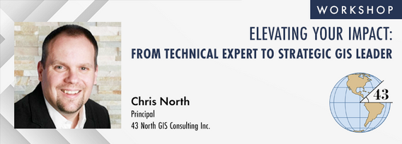
The role of GIS in almost all organizations is evolving from a technical system to an integrative, enterprise-wide capability that provides a unique perspective to solve many business challenges. This half-day workshop is intended to help existing GIS professionals, and those new to GIS in a management position, transition from a technical "What and How" focus on GIS technology to a strategic, value-oriented "Who and Why" mindset around what a GIS can contribute to the organization. The works...


The intent of this workshop is two-fold. First, to provide an introduction to an Open-Source based stack. Second, to provide insights on the use of Open GIS standard formats to power an organization's geospatial applications.To cover the first intent, we will look into the following components:QGIS: The Swiss Army knife for geospatial enthusia...