
Originally from Ottawa, Ontario, Sharon K.Y. Lee did her Bachelor of Science Honours in Geology at the University of Ottawa, She then completed a joint graduate program with the Centre of Geographic Sciences and Dalhousie University in Nova Scotia, where she obtained an advanced diploma in Remote Sensing and a Master of Science in Earth Sciences, respectively.
Sharon has gained valuable work experience over the years in database management and applying geomatics to various fields of geology in academia, government and the mining industry in Ontario, Nova Scotia, Quebec and Manitoba. In late 2019, she returned to her hometown to work as a geoscientist in the Infrastructure, Water Services Department at the City of Ottawa, where she is the program lead of the Geoscience Information Platform program.
Sessions in which Sharon K.Y. Lee participates
الأربعاء 15 مايو, 2024

The City of Ottawa (City) annually invests about $3M in studies of the local subsurface geotechnical, hydrogeological, and environmental conditions in support of municipal planning, development proposals, infrastructure designs, construction, and environmental protection studies. Much of this valuable information remains with individual consulting firms and in City project files, so this data is relatively inaccessible and not ready for use to internal and external stakeholders.
Sessions in which Sharon K.Y. Lee attends
الثّلاثاء 26 مارس, 2024

Airborne Topo-Bathymetric Lidar Combined with Thermal Imaging for Fish Habitat Studies in RiversResearchers at Nova Scotia Community College’s Applied Geomatics Research Group have been using the airborne Leica Chiroptera 4X topo-bathymetric lidar sensor for nearly a decade and have surveyed coastal, riverine and lake environments. They have concentrated on mapping submerged aquatic vegetation (SAV). Topo-bathy lidar data of rivers provides an opportunity for improved flood hazard h...


The Canadian government first formally created LiDAR Guidelines in 2017. The document was updated in 2022 to Version 3.1. This session will review the Canadian Guidelines and compare them to the USGS LiDAR Base specification, updated in 2023. Included in the presentation will be:LiDAR for Flood Mapping and funding from the National D...

الأربعاء 27 مارس, 2024

The United States’ National Geodetic Survey (NGS) plans to modernize their National Spatial Reference System (NSRS) in 2025, including adopting a new dynamic geometric reference (the North American Terrestrial Reference Frame of 2022 (NATRF2022)) and a new geoid-based height system (the North American-Pacific Geopotential Datum of 2022 (NAPGD2022)). To ensure continued geospatial referencing compatibility, the Canadian Geodetic Survey (CGS) plans to modernize the Canadian Spatial Reference Sy...

الثّلاثاء 14 مايو, 2024
Mini Continental BreakfastGeoIgnite is delighted to offer a selection of chilled fruit juices, freshly baked croissants, muffins, and breakfast pastries, served with butter and preserves. Guests can also enjoy fruit cocktails and yogurt. Available beverages include coffee, tea, and decaffeinated coffee.

Connecting the knowledge economy to the emerging relationship economy in a geospatial context. This talk will emphasize the growing importance of social skills and human connectivity in harnessing the power of data and technology. His talk, titled "Human Interoperability: Enhancing Geospatial Effectiveness in the Relationship Economy," explores the notion of valuing existing resources and optimizing the use of data and technology, particularly in the geospatial sector. As the Executive Office...

GeoIgnite is thrilled to present its keynote session, "Canada's Geospatial Leadership Panel," a gathering of some of Canada's most influential figures in the field of geospatial technology in Canada. Panelist: Melanie Desjardins, Director of the NWT Centre for Geomatics, showcases the application of geospatial technology in public sector management and natural resource governance. Her leadership in geomatics plays a significant role in shaping policies and strategies that utilize ...


In today's rapidly advancing technological environment, the imperative for robust digital governance has never been more critical. The rapid increase of digital technologies and data has underscored an necessity for standardized governance frameworks that not only bolster security and trust but also ensure innovation and efficiency across diverse global systems. This presentation will delve into the paramount importance of establishing and adhering to consensus-based standards in ...


Following the definition set out in the United Kingdom by Digital Built Britain, we understand a digital twin to be “...a realistic digital representation of assets, processes or systems in the built or natural environment…that adds social and economic value by augmenting the decision-making process.” Further, this digital representation has the capacity to exchange real time information with its physical twin and to use that information to learn, predict, or enact a possible response to a gi...


This presentation will explore how Sault Ste. Marie leveraged two decades of Geographic Information Systems (GIS) to craft and maintain its cutting-edge Digital Twin. Exploring the innovative applications of Sault Ste. Marie’s GIS digital twin model, which offers real-time insights allowing for collaboration and more effective decision making, this presentation showcases the transformative potential of GIS enabled digital twins. We will demonstrate how this comprehensive digital r...


Monitoring large numbers of activities and assets from space has long been an aspirational “holy grail” for satellite remote sensing. However, lack of observational cadence, collection capacity, sufficient resolution, multisource capabilities and contextual understanding of monitored sites has meant that true monitoring has been limited to a handful of key facilities and mission use cases. Will we as an industry be able to overcome current challenges and turn site monitoring into a mainstream...


The global OGC community continues to accelerate innovation, based on practical real world demonstrations of the art of possible for connecting and sharing data and information related to climate resiliency for disasters, climate monitoring for terrestrial and marine environments and more. This talk will provide a brief overview of the latest work, with a focus on "what is next?".


In the upcoming Canada's National Geospatial Conference, we are delighted to host a special plenary session, "Mapping the Future: Honoring Geoff Zeiss and His Transformative Work in Geospatial Technology," on May 14th in Ottawa. This session is dedicated to celebrating the remarkable contributions of Geoff Zeiss to the fields of mapping, utilities, and Geographic Information Systems (GIS).Geoff Zeiss, renowned for his insightful blog...


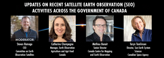
GeoIgnite is excited to present an all star panel discussion on earth observation in Canada. This panel brings together a trifecta of esteemed experts from various Canadian government agencies, with Steven Ramage, CEO of the Committee on Earth Observation Satellites (CEOS), serving as the moderator.Moderator: Steven Ramage, in his role as CEO of CEOS, brings a wealth of knowledge and experience in satellite earth observation. His expertise in coordinating international satellite earth ...


Get ready to mix, mingle, and enjoy an evening of delightful tastes and entertainment at the GeoIgnite Conference Social.Your conference registration includes a delectable assortment of culinary offerings prepared by the head chef of the OEC. Indulge in a variety of hot canapés, including Vegetable Spring Rolls, Spanakopita, Chicken Skewer and Lamb Spiedini. Our cold selection features Cucumber with Dill Cream Cheese and Shrimps, Bri...