
Abdurrahim Hocagil
Sessions in which Abdurrahim Hocagil attends
الأربعاء 21 أبريل, 2021

Join us for the the launch of GeoIgnite with Jonathan Murphy, the Chair of GeoIgnite, and Dr. Minda Suchan of MDA.Abstract of MDA Keynote: Canada is the world leader in wide area space-based radar Earth observation through the highly successful RADARSAT program, supporting numerous operational and scientific uses for Synthetic Aperture Radar (SAR) data. MDA, in conjunction with the Canadian government, has created an internationally recognized brand and reputation for...


Do you know what the geospatial product trap is? We fall in love with the technology, not the problem. I am a lucky person. My job has evolved to one where I primarily get to talk about geospatial technology all day. I could be scoping out internal or external projects or evaluating technologies. Increasingly, I provide advice on product ideas. This final situation has forced me to consider the nature of our community-of-practice. The common assumption that geospatial ...

The Canadian Centre for Mapping and Earth Observation (NRCan) continues its work to implement the National Elevation Data Strategy. Through this strategy, one of NRCan's goal is to provide Canadians with an accurate three-dimensional representation of the country, in support of government priorities such as flood mapping. Because of the enormous task of obtaining a high-precision and up-to-date national elevation layer, NRCan works with different entities.The data coverage of the st...

Over the past year, Minerva Intelligence, a Vancouver-based cognitive AI company, has been awarded two contracts with Natural Resources Canada to design schemas at a national level: the National Flood Hazard Data Layer (NFHDL) and the National Hydro Network V2 (NHNv2). You might be asking yourself why an AI company is designing and building these important database structures. Minerva's cognitive AI system makes use of semantically inoperable data in knowledge graphs and has designed syste...

À l'automne 2020, NV5 Geospatial, propulsé par Quantum Spatial, a été mandaté par la Communauté Métropolitaine de Montréal (CMM) pour réaliser l'un des plus grands levés lidar topobathymétriques aériens fluviaux jamais entrepris au Canada. Cette présentation examinera de plus près le contexte, les objectifs, les défis, la technologie, la méthodologie, ainsi que les résultats et conclusions préliminaires de cette importante étude aérienne des vingt-huit principaux cours d'eau entourant la v...

Explore the structure of an enterprise location intelligence platform at Agriculture Agri-food Canada and how they created a strategic road map to systematically diagnose strengths and weaknesses to drive the use of location intelligence in everyday program and policy decisions of a federal department.Agriculture and Agri-Food Canada supports the Canadian agriculture and agri-food sector through initiatives that promote innovation and competitiveness.

Maxar is building the highest resolution and most accurate 3D map of the planet and this talk will provide an overview of the products and capabilities that are making it possible.

Title: Advancing Space Based Observation in Canada:The GeoIgnite 2021 Directors General Geospatial Panel, part of Canada's National Geospatial Conference.Title: Advancing Space Based Observation in CanadaThis is a must attend panel for anyone interested in learning the direction Canada's Federal government geospatial leadership is taking.Join our panelists for an exploration of Canada's geospatial priorities and mission in this exciting discuss...


الخميس 22 أبريل, 2021

Abstract forth coming: Oversight for CSA program sectors, including in Space Utilization, Space Exploration, and Space Science and Technology.


At a time of rising climate change impacts, there is a vital and growing need to prepare for, respond to, and recover from natural disasters. But there is a critical communication gap between authorities and citizens. Drawing on the results of our massive multi-year climate change R&D project, and with assistance from hundreds of students, citizens, academics, NGOs, and government officials, we have identified the top perceived climate change-relatedcommunication problem...

Join us April 22nd for a Fireside Chat with Dr. Steve Liang, Founder and CTO of SensorUp. Professor and Rogers IoT Research Chair at University of Calgary and Dr. Nadine Alameh the OGC’s Chief Executive Office (CEO).Steve's goal is to disrupt the silos of the Internet of Things by creating, using, and implementing open and interoperable standards and products for device-cloud communications and cloud-cloud communications. Steve is chairing and the editor of several key IoT enabling...


In this presentation, Dr. Walter Scott will compare the satellite imaging constellations of Maxar and other commercial companies to show how they stack up in three key metrics: product-market fit, adaptability and capital efficiency. He will also share some key insights on the next generation of Earth Intelligence arriving in 2021 with the launch of WorldView Legion, and what impact that will have for the Canadian geospatial market in the months and years ahead.

Applying SafeGraph’s Canadian POI data for community-level analysis in ArcGIS and TableauGeospatial data empowers research bodies, government agencies, and the private sector to visualize and analyze complex problems in new and innovative ways. But location data is only valuable if it is accurate - something many GIS and data analysts know all too well. Armed with accurate, precisely geocoded POI data that includes key attribution related to brands and business types, analys...

For nearly 50 years, geomatics representatives from Canadian provinces and territories have collaborated together and with the federal government on geomatics initiatives. This presentation will explore why such a council came to be and why its work matters to the Canadian geomatics sector and citizens alike. While the geomatics sector and the world we live in continue to change, the need for coordination across jurisdictions remains crucial to support decision-making and response to share...

The Canadian Geodetic Survey (CGS) of Natural Resources Canada (NRCan) is responsible for defining, maintaining, and providing access to the Canadian Spatial Reference System (CSRS). The CSRS provides a consistent reference for surveying, mapping, and other applications which require accurate positioning. This presentation will describe the CGS products, tools and services which are currently available and provide access to the Canadian Spatial Reference System (CSRS). It will also take a ...

With PetaBytes of data flowing out of Low Earth Orbit everyday, the opportunity afforded by Earth Observation seems to be greater than ever. But is our community realizing that opportunity yet? Are there winners? How should we be thinking about EO businesses in the roaring 2020s?


الجمعة 23 أبريل, 2021

The global geospatial industry is estimated at US$ 500 Billion and delivers an even more significant impact on society, with derived economic benefits estimated to be multifold. These benefits, however, are still not fully understood by key stakeholders and policy and decision-makers, ultimately hindering the global uptake of geospatial information. With decades of national spatial data infrastructure efforts around the world, how can this be? Focusing on the importance of...


In this presentation by Avenza Systems, we will be showcasing how high quality cartographic outputs after your data analysis can actually be achieved! We will demonstrate how to develop and design a map from raw statistical census data in Adobe Illustrator by leveraging the geospatial functionalities of MAPublisher - the industry-standard cartography solution for high quality graphical output. We’ll show how GIS data can be imported, managed, and transformed on-the-fly all d...

In 2003, when GISPartner entered the business Poland was still far behind more developed countries in terms of IT implementation. In 2021 the gap is incomparably smaller and some of Polish IT solutions are widely used across the globe. When public administration is considered, it was also GISPartner, which greatly contributed into transforming paper & stamps into high-class software solutions. We want to share our thoughts on how clever, tailor-made IT solutions are driving this transf...

With rapid advances in Earth observation, cloud computing, and analytics technologies, more information on our changing world is more readily available than ever before. Planet is an aerospace and data analytics company at the forefront of these advances -- working to make global change visible, accessible, and actionable, Planet images the full Earth daily at 3.5m resolution and anywhere sub-daily at <50cm. In this talk, we’ll hear from Tara O’Shea, Planet’s Director of Forest Programs, o...

The Government of Canada and organizations such as the UN recognize the critical role of standards in geographic information and geomatics to support stewardship and interoperability of information, ensuring that organizations access, use and share geospatial data efficiently and effectively to support program and service delivery to Citizens. The data inventory/catalogue and the supporting standards are foundational components of any national geospatial information framework. As such, wel...

This talk will be bringing together the power of location intelligence and blockchain technology for an increased speed and accuracy of transactions and improved decision-making.The value that blockchain brings to geospatial technology is security, immutability, and trusted data. On the other hand, geospatial technology provides the power of location to the blockchain. Together, they represent a game-changer both for their utility and disrupt...

Join GeoIgnite for this inaugural panel of provincial and territorial geospatial and location technology leaders.We will be discussing issues surrounding: What are main priorities and challenges across jurisdictions? What types of geospatial tools we use to monitor and respond to key challenges like emergency response? How are jurisdictions aligning geospatial tools, data, and people to address climate change? What are some current data...


الإثنين 26 أبريل, 2021

PLEASE NOTE THE PREFERRED BROWSER IS GOOGLE CHROME. If you are running into any issues accessing the session, please try logging in via Google Chrome.The use of drones or UAVs has expanded dramatically over the last few years and this technology is rapidly permeating a wide variety of professional disciplines and industries, including the broad field of GIS. Ideally suited for on-demand geospatial data collection, drones can effectively eliminate the logjam tha...

الثّلاثاء 27 أبريل, 2021

Google Chrome is the preferred browser for this session.Tickets for this workshop must be claimed in advance.This session will occur from 10:00AM-11:00AM and repeat again from 11:00AM-12:00PMBeSpatial is a geospatial community platform in Ontario that has opened doors to connect, communicate and innovate. BeSpatial aims to provide networking opportunities, programs, and ...

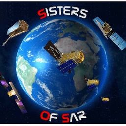
Google Chrome is the preferred browser for this session.Tickets for this workshop must be claimed in advance.Have you ever wanted to learn more about Synthetic Aperture RADAR (SAR) and Electo-Optical (EO) products? Come join this session for an introduction to some of the basic imaging parameters and learn about the different p...

Google Chrome is the preferred browser for this session.Tickets for this workshop must be claimed in advance.This workshop will be broken down into 4 parts:1. Introduction to ERDAS IMAGINE2. Spatial Modeling for Wildlife Applications3. Using AI, Spatial Modeling and Python to Break Down Big Data Barriers4. Q & ASpatial Modeling ...

الأربعاء 28 أبريل, 2021

Dr. Gordon “Oz” Osinski is a Professor and the NSERC/MDA/CSA/CEMI Industrial Research Chair in Earth and Space Exploration in the Department of Earth Sciences at the University of Western Ontario (Western), Canada. He holds a PhD from the University of New Brunswick (2004) and a BSc (Hons) from the University of St. Andrews (1999), Scotland, both in Geology. Dr. Osinski’s research interests are diverse and interdisciplinary in nature. His main area of research focuses on understanding impact ...


Tickets for this workshop must be claimed in advance.The use of drones, officially referred to as Remotely Piloted Aerial Systems (RPAS), has been forecasted to play a key role in the digitalization and further optimization of a variety of geomatics applications such as in resource aggregates management, landfill management, civil engineering (3D reality capture, virtual surveying), and precision agriculture. To help realize this forecast it is important for ...


Sometimes your vision of what your career path will be and what it actually ends up being can be quite different from one another. Dr. Tanya Harrison will discuss her somewhat non-traditional and non-linear pathway through academia and into the space industry, focusing on topics such as transferable skill sets and not being afraid to take a detour—or a different path entirely—if an opportunity or speed bump arise.

As examples of various online map styles and techniques, Dave prepares maps of pictures of Earth taken by astronauts and cosmonauts onboard the International Space Station. These are also "of interest" to many in the general public. In this talk, he'll dive into some favourites photos, some of the mapping techniques, and some interesting anecdotes along the way. View the whole set of maps at https://isspix.com/MapTourHowTo

SmartICE is an internationally recognized work integration social enterprise (WISE) that empowers Indigenous communities to adapt to increasingly unpredictable ice conditions. It is the world’s first climate change adaptation to integrate Indigenous knowledge of ice safety and travel with advanced data acquisition and remote monitoring technology. As a social innovator, SmartICE harnesses the vast potential of Indigenous women and men—especially youth—to embrace science, technology and tra...
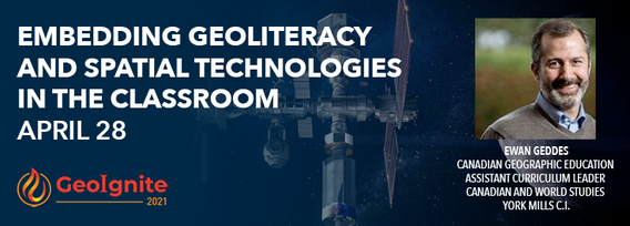
The presentation will focus on strategies of how to embed geoliteracy and geospatial technologies by using the Ontario Curriculum as a platform. Participants will examine exemplars of activities that incoporate geoliteracy and geotechnologies to engage students as well as methods on how to create activities that focus on geoliteracy and technology.

Geography plays an important role in being a parent and a teacher. Developing geographical perspectives gives a sense of understanding cultural connections and the complexity of building relationships. The connections of understanding the purpose of our actions towards physical and human sustainability. It is a lens of perspective understanding that defines human actions and connections.


الخميس 29 أبريل, 2021

The Canadian Cartographic Association (CCA), is a National non-profit organization that helps advance geographic education in Canada through the use of mapping technology. We host annual cartography related conference and events, and promote geography awareness through scholarship and awards. CAA membership is open to anyone with an interest in any aspect of mapping. If you have a passion for maps then we encourage you to check out our website https://cca-acc....

Tickets for this workshop must be claimed in advance.This workshop will offer a deep-dive into the Avenza Maps app, a mobile app where users can upload or access custom maps for off-line navigation, way-finding, and data collection. The workshop will be composed of 5 modules covering the fundamentals of the apps usage, as well as more advanced industry-relevant features. We will also provide a walkthrough of using the Av...


الثّلاثاء 1 مارس, 2022

In Budget 2021, the government tabled a recovery plan for jobs, growth, and resilience. Within the budget were specific investments to promoting a healthy environment for a healthy economy, with $145.5 million dedicated to supporting initiatives that will increase resiliency to the natural hazards of wildfires and floods, which are becoming more frequent, severe, and devastating due to climate change and urban development. Flood hazard maps are essential to un...


Abstract: Organizations are increasingly relying on geospatial analysis to power their decision making and business processes. But in such a dynamically changing world, maintaining an accurate database of critical locations is no small task. Everyday worldwide, businesses open and close, change names, or update their operating hours. When these changes happen, any map, application, or model immediately becomes stale. How can organizations strategize if they are not...


NV5 Geospatial has been at the forefront of hydrospatial data acquisition and processing for decades. This presentation will provide a brief corporate introduction and overview of some of the technologies relevant to remotely sensed hydrospatial data collection and development. This will also include associated analyses and ancillary data integration to solve questions surrounding hydrology and wetland mapping, flood risk modeling, and habitat...


الخميس 3 مارس, 2022

Sanjay Kumar is the founder and CEO of Geospatial Media & Communications. He also lends his time and experience to many organizations helping them to further the cause of increasing the impact of geospatial technology and its applications at a global scale.

الأربعاء 6 أبريل, 2022

In this informative discussion, learn how to easily display and manage mobile Lidar and static laser snap from a unique source of trustful data in the cloud. Key take-aways include:Turn structured and unstructured mobile point clouds in high-resolution 3D meshesMake the most of your static or indoor mobile scanners in a combined workflowEffortlessly use visual analysis to reconcile your BIM models to your scansUse cost effective pro...


Lidar! This ubiquitous 3D technology is transforming how we visualize, map and analyze the world around us. What is it and how does it fit into the remote sensing toolbox? This presentation provides an overview of the core advantages of lidar data and an overview of the latest sensor solutions from RIEGL.
