Tuesday 18 June, 2019

Jonathan Murphy the Founder of GeoIgnite and GoGeomatics welcome participants to the conference

Mayor Watson welcomes delegates, exhibitors and VIPS to the inaugural National Geospatial event in Canada.
There's never been a more exciting time to be a part of the geospatial profession. From mapping the infrastructure beneath our cities to indoor wayfinding, to plentiful and powerful remote sensing capabilities in air and space which we could hardly have imagined just a few years ago, the opportunities - and the expectations - for geospatial professionals are immense. Technology is evolving at a pace which outstrips the ability of academics, governments, and industries to keep pace. How will w...

Let’s admit it! We live in exciting times with technology, social interactions and business models changing before our eyes: Flying taxis, self-driving cars, commercial Space missions, smart cities, SmallSats and Internet Of Things (IOT) to name just a few innovations! Our kids are growing up in a world of on-demand TV, GPS availability, all around virtual assistants, and mobile devices that pretty much can do anything! Each and every one of these innovations has a location element to i...
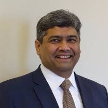
Prashant Shukle is the Director General for the Canada Centre for Mapping and Earth Observation Branch, Earth Sciences Sector, at Natural Resources Canada (NRCan).NRCan has fostered an enabling policy mechanism and provided a conducive framework for geospatial information infrastructure. In today’s digital age when geospatial is becoming more and more ubiquitous, open and inter-disciplinary policies are the key instruments of harnessing the true value of this wonderful technology...
What are the ramifications of the current digital transformation globally and what will it mean for Canada and the globe? Our award winning panel of international and Canadian experts disscuss and take questions from delegates.


Break

Alberta View: Economic impacts and Opportunities of the Geospatial SectorLocation technologies are changing the way we live, work, and play, and are having a transformative impact on industries across Canada. The intersection of location technologies with Virtual Reality and Augmented reality are rapidly transforming key sectors of the Canadian economy including transportation, the resource sector, the digital and interactive media sector and transforming how governments d...

The future is digital. Big data is an integral part of the digital transformation of a private or public organization. Location and geospatial technologies are at the heart of the digital transformation as enablers, game changers and contribute to the success of big data in many ways. Combined with emerging geospatial artificial intelligence, the possibilities are limitless. Smart cities and autonomous vehicles are examples of this potential. However, this big data revolution raises many lega...

Several key trends in the geospatial industry over the last few years have created the conditions needed to truly leverage remote sensing as a technology that has the potential to provide tremendous benefit to civil society. These include changes in data policy, most notably with USGS's decision in 2008 to make all Landsat archives free and open, a policy which led the European Space Agency to also implement free and open access to the Copernicus constellation. The volume of data that is incr...

Hope Spots are special places that are critical to the health of the ocean — Earth’s blue heart. Some Hope Spots are already formally protected, while others still need defined protection. The Mission Blue team has embarked on a series of expeditions to shed light on these vital ecosystems and ignite support to safeguard them as marine protected areas.The IUCN are an integral partner in the Mission Blue initiative and the Hope Spot concept ties into UN amb...

Global Grid Systems is pleased to sponsor the first lunch of the conference. GeoIgnite offers our delegates a special meal for the first day of the event. Executive Chef Derek Ragnitz has put together a delicious and healthy lunch.Geoignite Day 1 Mediterranean Style Lunch:Medley of mixed greens cherry tomatoes and cucumbers with dressings.Traditional Greek salad, freshly made hummus with tabbouleh and pita bread.Grilled M...

Today, geospatial technologies are embedded in many of the workflows that support the Fourth Industrial Revolution and therefore invaluable to users. This means that geospatial information is no longer the domain of specialists and suddenly has become a context for the rest of our augmented existence.From Pokémon Go, to Uber and autonomous vehicles (AV), Internet of Things (IoT) and Artificial Intelligence (AI), smart applications and on-line mapping tools give the public almost insta...

The Internet of Things (IoT) is here. Whether applied to industrial automation, wearables, connected transportation and logistics, drones or smart cities, IoT is poised to disrupt how we work, live and relate to each other, delivering great benefits along with new challenges. Improved revenue, costs, quality of life and convenience benefits are often confounded by concerns such as privacy, security, and social disruption, with location info playing no small role on both sides. So, what exactl...
The UK Government as part of its building information modeling (BIM) initiative has said repeatedly that it expects the big payoff of a digital model will be during operations and maintenance, which typically represents 80% of the cost of a facility. Companies who do design, build, finance, and maintain, or design, build, operate, or PPP projects often employ a full lifecycle BIM + geospatial strategy. For example, Crossrail appears to be the first major project that may be able to provide su...
The Earth is immense, and abundant with interesting information. Recent advancements in geospatial sensors (e.g. satellites, smart phones, meteorological instruments, and LIDAR) have resulted in the development of technologies capable of collecting large and dynamic geospatial data. As a result, we are experiencing an explosion in the volume and variability of geospatial data, and yet many in public remain unaware of or unable to access this wealth of data to make informed decisions regarding...


Cloudy with a chance of data science.Sparkgeo had been building cloud first geospatial applications, from day 1. But that was not the plan. The plan was to make more maps for more people, using the internet.Sitting at the intersection of software development and GIS we see how these two communities can benefit from each other. But, to do so, we will have to step out of our comfort zones.Let me tell you the story of a lowly GIS tech's journey through the technol...

The Mapbox live location platform was designed to serve all levels of government and the critical services they support. Develop custom mapping and location applications from start to finish in your own private cloud or on-premises infrastructure. Atlas offers the same capabilities found on Mapbox.com only offline, and deployable anywhere, even on your own infrastructure. Learn more about accessing and analyzing your sensitive geospatial data on and off network during this 30 minute session. ...

We are entering a new era of positioning, navigation and timing. Global, instantaneous, and easily accessible positioning at better than 10cm is coming, which will provide new ways of doing business and create new businesses in areas such as augmented reality. In recent years global Positioning, Navigation and Timing have been undergoing rapid technological development. New GNSS constellations (Galileo, Beidou) with new signal structures offer increased capabilities, while future posi...

Please join fellow conference attendees for an amazing networking reception in the exhibitor hall sponsored by Mapbox. The event will feature surprise performances and appetizers, and will be a great chance to connect with other geospatial professionals.