
Lindsay Beardsall
Sessions auxquelles Lindsay Beardsall assiste
Mardi 14 Mai, 2024

Connecting the knowledge economy to the emerging relationship economy in a geospatial context. This talk will emphasize the growing importance of social skills and human connectivity in harnessing the power of data and technology. His talk, titled "Human Interoperability: Enhancing Geospatial Effectiveness in the Relationship Economy," explores the notion of valuing existing resources and optimizing the use of data and technology, particularly in the geospatial sector. As the Executive Office...


GeoIgnite is thrilled to present its keynote session, "Canada's Geospatial Leadership Panel," a gathering of some of Canada's most influential figures in the field of geospatial technology in Canada. Panelist: Melanie Desjardins, Director of the NWT Centre for Geomatics, showcases the application of geospatial technology in public sector management and natural resource governance. Her leadership in geomatics plays a significant role in shaping policies and strategies that utilize ...


In today's rapidly advancing technological environment, the imperative for robust digital governance has never been more critical. The rapid increase of digital technologies and data has underscored an necessity for standardized governance frameworks that not only bolster security and trust but also ensure innovation and efficiency across diverse global systems. This presentation will delve into the paramount importance of establishing and adhering to consensus-based standards in ...


Following the definition set out in the United Kingdom by Digital Built Britain, we understand a digital twin to be “...a realistic digital representation of assets, processes or systems in the built or natural environment…that adds social and economic value by augmenting the decision-making process.” Further, this digital representation has the capacity to exchange real time information with its physical twin and to use that information to learn, predict, or enact a possible response to a gi...


This presentation will explore how Sault Ste. Marie leveraged two decades of Geographic Information Systems (GIS) to craft and maintain its cutting-edge Digital Twin. Exploring the innovative applications of Sault Ste. Marie’s GIS digital twin model, which offers real-time insights allowing for collaboration and more effective decision making, this presentation showcases the transformative potential of GIS enabled digital twins. We will demonstrate how this comprehensive digital r...


Monitoring large numbers of activities and assets from space has long been an aspirational “holy grail” for satellite remote sensing. However, lack of observational cadence, collection capacity, sufficient resolution, multisource capabilities and contextual understanding of monitored sites has meant that true monitoring has been limited to a handful of key facilities and mission use cases. Will we as an industry be able to overcome current challenges and turn site monitoring into a mainstream...


Public Safety Canada has a mandate to keep Canadians safe from a range of risks, including natural disasters, and has taken recent steps to incorporate the use of data and science into all aspects of Emergency Management. In 2020, Public Safety stood up the Data Science and Engineering Team (DSET) to provide technical expertise and quantitative risk analysis in support of major policy programs, including Flood Insurance, ...


The global OGC community continues to accelerate innovation, based on practical real world demonstrations of the art of possible for connecting and sharing data and information related to climate resiliency for disasters, climate monitoring for terrestrial and marine environments and more. This talk will provide a brief overview of the latest work, with a focus on "what is next?".


After a description of the Canadian Space Agency (CSA)'s mandate and mission, an overview of the different sectors in the Canadian Space Agency that touch on geomatics, is given. Different roles are described and the relationships with external entities as part of these roles. Examples of profiles of people at CSA are given.
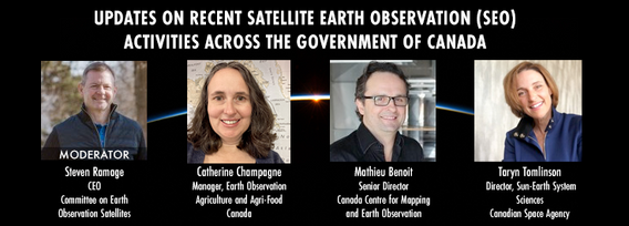
GeoIgnite is excited to present an all star panel discussion on earth observation in Canada. This panel brings together a trifecta of esteemed experts from various Canadian government agencies, with Steven Ramage, CEO of the Committee on Earth Observation Satellites (CEOS), serving as the moderator.Moderator: Steven Ramage, in his role as CEO of CEOS, brings a wealth of knowledge and experience in satellite earth observation. His expertise in coordinating international satellite earth ...


Mercredi 15 Mai, 2024

The domains of BIM and GIS have historically been separate areas of expertise and been considered distinct and separate domains. However, the need for geospatial technologies to integrate with Building Information Modeling (BIM) design applications and the need for BIM geometry and data to be applied in Geographic Information Systems (GIS) is becoming more prevalent. In the rapidly evolving period of urban development, BIM and GIS emerge as pivotal technology tools shaping the future of...

As evidenced by the 2023 fire season, we are experiencing unprecedented fire management challenges in Canada. Innovative fire monitoring solutions can help support wildfire managers as they limit the negative impacts of wildland fires while also prioritize the positive benefits in Canada’s forested ecosystems. Opportunities for advancing fire monitoring mirror a broader paradigm shift in the field of Earth observations towards open data, large-scale analyses, and collaborative development. In...

The Department of National Defence, as steward of a real property (RP) portfolio that includes tens of thousands of buildings and supporting infrastructure, is seeking to manage its Real Property (RP) assets more effectively by modernizing and improving its digital capability. In this effort, interoperability between BIM and GIS through open data standards is crucial to enable the Integrated Digital Built Environment. BIM allows representation of detailed information regarding building elemen...


The Carleton University Immersive Media Studio (CIMS) was awarded a New Frontiers in Research Fund (NFRF) Exploration program grant to Imagine Canada’s Digital Twin. One aspect of the project is data governance and business models. In addition, the I Trust AI research SSHRC funded project based out of UBC, is examining the CIMS and city of Ottawa Digital Twins to assess how their creators might include preservation in their design. These research projects revealed that the Architecture, Engin...


GeoIgnite is proud to present a vital panel discussion titled "Bridging Worlds: Integrating BIM and GIS for a Digital Future in Built Asset Management," featuring distinguished panelists Susan Keenliside, Deputy Director at the House of Commons of Canada, and John Hale, Vice-President of buildingSMART Canada and BIM lead at the Department of National Defence. The session will be moderated by Trevor Taylor of the Open Geospatial Consortium (OGC).


Remotely Piloted Aircraft Systems (RPAS), or drones, are becoming more common in the construction industry as a key tool to complete complex building and infrastructure projects. As technology improves, the barriers to adoption are reduced, creating a huge opportunity for the industry to improve the construction process and support the ongoing digital transformation. Drones boost productivity by enabling construction teams to rapidly and easily survey job sites, track progress, and spot poten...


buildingSMART and the Open Geospatial Consortium have recently published the results of their collaborative effort aimed at developing a joint roadmap toward seamless information continuity between BIM and GIS domains. This session will provide insights regarding this collaborative effort and the joint roadmap between both organizations, which aims to enhance alignment between the two industry bodies on this critical subject. Discover how this roadmap has been crafted to capitalize on global ...


Climate change presents an array of unprecedented challenges to global resilience and sustainability. As the urgency to address these challenges increases, the role of geomatics as a cornerstone technology for enabling climate resilience becomes ever more significant. This panel discussion, moderated by Tanya Harrison of the Earth & Planetary Institute of Canada, will explore the transformative potential of geomatics in bolstering climate resilience.


The presentation will be focused on the deployment of technological processes on the Centre Block Rehabilitation project and illustrate how the team is managing and manipulating different forms of asset element data for distribution and coordination among an exceptionally large subset of stakeholders, each with their own complex set of requirements and governance policies. Several technologies have been developed and employed to consolidate data from multiple sources so that current and futur...
