Matt Wilkinson
Elementy, w których Matt Wilkinson attends
poniedziałek 6 listopada, 2023

Join us as we open the GoGeomatics Expo with a memorable evening filled with delicious food and great conversation! Elevate your Expo experience and forge valuable connections with fellow attendees, exhibitors, speakers and panelists. Following dinner, there will be a special panel moderated by GoGeomatics founder...

Step into the exciting realm of the inaugural GoGeomatics Expo in Calgary, a historic event that is set to make waves in Canada's geospatial sector. This compelling panel discussion will delve into the groundbreaking significance of this first-of-its-kind expo, exploring why it is a game-changer for both the public and private sectors, and how it charts a new course for the geospatial industry in Canada. This panel discussion takes place after the expo reception buffet. Participants must b...


wtorek 7 listopada, 2023


Since 2018, students from geomatics programs across Canada have been participating in the annual National Geomatics Competition. Now in it's 5th year, the University of Sherbrooke will be hosting the next iteration in March.We invite you to participate in this discussion around the opportunity for industry and academia to meet at NGC 2024.


SUMMARYWith the increasing focus on damage prevention, public safety concerns, and environmental damage due to underground utility strikes, it has become more critical to accurately locate, store, and be able to visualize subsurface utilities. We show several key technical and business details when implementing a subsurface mapping system from data collection to the use of machine learning for 3D modelling and visualization and give real-world examples and use cases of the different le...

What are the trends in education, technology, policy, perception and markets that will mold the future of Geomatics – and how has the profession responded? The presenter has worked in and written about numerous aspects of surveying for several decades and views the future of the profession as one of both challenges and opportunity – new, exciting and sometimes surprising opportunities. This session will be interactive, challenge conventional wisdom, poke a little fun, and hopefully provides s...

Is change the new normal? Every year seems to be the next warmest year. Those of us looking back at our planet from space are seeing these changes across our planet in near real-time through the eyes of satellites. But behind those pixels are real human stories of catastrophe and suffering. So, with all our constellations of satellites, massive computing power and new generative AI algorithms, can we do anything more than simply report what happened? What does the future hold for geospatial t...


Over his decade plus at Suncor, Alonzo has been both witness to and active participant in a quiet digital Geospatial revolution. This revolution has democratized access to Geospatial data and tools to everyone at Suncor. Which meant that teams and professionals across a myriad of disciplines have embraced and pushed the limits of Geospatial data and software. The constant demand for newer and higher-resolution data has relegated the paper map to secondary status as the tool for spatial commun...


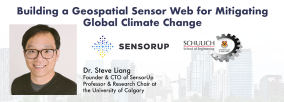
With climate change comes a massively increased risk to billions of people due to disasters, reduced food and energy security, environmental degradation, and sea level rise to name a few. For example, it is estimated that 200,000,000 people live in low-lying areas of the world considered highly vulnerable.The global OGC community has mobilized to improve how well we connect land, sea, and air Geospatial data and information, improve regional connectivity between various SDIS &nbs...


Join us at the GoGeomatics Expo in Calgary for a concise panel discussion on the present and future of geomatics education. Our panel, comprised of professors and industry experts, will address the following key topics:1. Current State of Geomatics Education:Explore the status of geomatics education in Canada.Understand how educational programs are adapting to ind...


At the Earth Observation for the Environment Laboratory in The University of Calgary, we have been conducting research in developing remote sensing-based forecasting system for forest fire danger conditions since 2009. In the scope of this presentation, the chronology of such developments at daily, 4-day, and 8-day time scales will be discussed. We believe that these would be critical for managing forest fire regimes in Canada and elsewhere in the world.


Planet scans the entire land mass of the planet nearly everyday with high resolution multispectral imagery, enabling exciting new opportunities and solving old challenges for digital transformations and sustainable business acceleration. Now with our growing fleet of 8-band Superdoves in orbit, the launch of our Planetary Variables - daily soil moisture, temperature, crop and forest biomass, etc - we have evolved even greater capabilities for a new era of Earth Observation technologies. In th...

Addressing the escalating levels of methane in the Earth's atmosphere is among the most urgent issues humanity faces. Methane ranks as one of the most potent greenhouse gases (GHGs), trapping over 25 times more heat than carbon dioxide over a 100-year period; thus, significantly reducing methane emissions will make a substantial impact in the fight against climate change.One of the most impactful methods for mitigating methane emissions involves the prompt detection and repair of metha...


MAXAR Technology provides integrated space infrastructure and earth intelligence capabilities that make global change visible, information actionable and space accessible. MAXAR has been highly active in remotely sensed projects in Western Canada and this talk with discuss some of the current applications using high resolution data across a number of important sectors. Moreover, it will discuss the current and future platforms that are bei...

LiDAR continues to be a cornerstone of the mapping industry. Since its inception, the technology has evolved from sole use on manned aircraft to being used on UAVs and mobile mapping platforms. As the LiDAR industry continues to evolve, our panel of experts will discuss what current and future trends impacting this industry. Join our award-winning panelists for an exciting discussion. Bring your questions.

In February 2022, Balko Technologies, a Quebec-based company, launched the world's first modular drone Lidar, which aims to democratize geospatial data capture by offering a versatile, easy-to-use and quick to deploy solution. This technological showcase aims to demonstrate the performance, modularity and distinctive advantages for users of our brand new Connectiv solution and its e-LAS software, developed by a team of experts with more than 10 years of experience in airborne data capture....


In the face of escalating environmental challenges, Canada grapples with the urgent need for advanced solutions in wildfire monitoring, emissions reduction, and natural resource management. This panel discussion explores how the burgeoning "New Space" frontier offers innovative approaches to address these critical issues.We aim to provide a platform for various industry players to share their own innovative technologies and insights, creating a vibrant dialogue on crucial geospatial...


Flooding is Canada’s most costly natural disaster, and flood risk intensifies as a result of urbanization and climate change. These impacts will change over time and can jeopardize the overall sustainability of communities if they remain unaddressed. As socio-economic consequences worsen, it underlines the need for governments to provide current and accurate hazard information to vulnerable populations, including Indigenous communities who are disproportionately affected, to make decisions...


Menu - Big Four OutletAppetizersRoasted Diablo Pork Bites (12) (GF/DF) SaladsSpiced Cauliflower, Chickpea & Tofu Bowl (GF/DF/V/VE) Sweet Potato, Roasted Cauliflower, Chickpeas, Mint Chutney,Grilled Tofu, Madras Curry DressingClassi...

With an increasing multitude of new Earth Observation (EO) satellites, it is imperative for the geomatics community to assess the fit of these emerging space assets. This presentation aims to provide a comprehensive analysis of the diverse range of EO satellites currently being deployed, and their potential applications.Topics:1) An Overview of the recent surge in EO satellite launches2) New satellite capabilities, and use cases3) An exploration of the challenges customers ...


There is a pressing need for a global change detection system capable of persistently monitoring the entire earth with globally consistent coverage, temporally consistent sampling, scientific-grade geometric and radiometric quality, and cost-effective management of daily data. These four conditions enable near real-time monitoring and retrospective change detection applications while minimizing false positives and the required work to develop, maintain, and run harmonizing a...

The GoGeomatics Expo and our sponsors are proud to present the Diversity in Leadership Panel.As the common goals of diversity, equity, and inclusion become even more widespread, organizations have the daunting task of figuring out what works.It is our vision the expo will spur the grassroots of a more diverse ecosystem where diversity of thinking and knowledge w...


Join Canadian GNSS manufacturer Eos Positioning Systems for an in-depth look at using the high-accuracy Arrow Gold+ GNSS Receiver with RTK corrections and Esri’s ArcGIS Field Maps.In this live and interactive presentation, you will learn how to do the following:1. Add GNSS metadata fields to ArcGIS Field Maps 2. Easily connect to the local RTK network to achieve real-time <2cm accuracy in the field 3. Collect high-accuracy data in the field according to best...

Creating, managing and sharing geospatial information has never been easier, but how do we ensure the information we are using to make key business decisions is current, correct, accurate and the best fit for purpose? This session will explore the different types of geospatial information assets being used at The City and the different tools, methods and standards that are being used capture, manage and share authoritative City data across the organization and to the Citizens of Calgary.


Join us at the BIM/GIS panel of our conference as we delve into critical subjects shaping the intersection of Building Information Modeling (BIM) and Geographic Information Systems (GIS). Our expert panelists will explore the evolving landscape of BIM and GIS, offering invaluable insights into various aspects of this dynamic field.Agenda:The Importance of Standards and Interoperability...


As GIS professionals, we understand the pivotal role that geospatial data plays in decision-making across various industries. Now, imagine harnessing that power to transform facility management. This presentation delves into VertiGIS FM, a groundbreaking solution that revolutionizes facility management through the lens of spatial intelligence, creating new opportunities and efficiencies across organizations.

Join us for an immersive and interactive workshop led by the founder of Cyanic Automation, Doug Kondor. In this engaging session, you'll delve into the world of project management in the context of land surveying, guided by an industry expert with a passion for innovation.Workshop Highlights:Theory Meets Practice:Doug Kondor goes beyond theory, offering a hands-on journey through the best practices of project management. Learn how to bridge ...
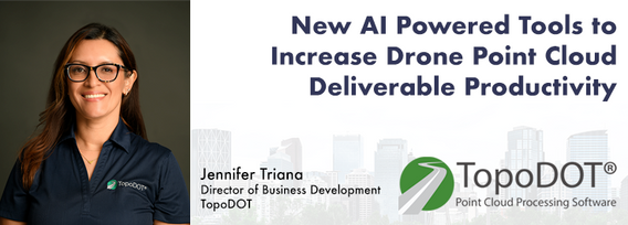
Learn how newly implemented surface modeling tools employing artificial intelligence reduce the turnaround time of point cloud surface models by 400% while maintaining high-fidelity results around break lines. Faster ground extraction routines for UAV data can be achieved without the need for classification or noise removal. In this presentation, we'll discuss several examples including how a query volume calculation project compared with traditional modeling workflows yielded nearly exact...


Harnessing the power of regular collection of imagery and Lidar, the City of Calgary provides valuable information for municipal service delivery. The City publicly shares various datasets in different formats, including Orthophotos, Lidar, and 3D buildings, oh-my! Beginning in 1990, the Aerial Imagery Program supported planning, development, and operations.Regularly collecting spatial data allows for more accurate assessments of changes over time. Annual Orthophoto collection aids in ...


The end of the first day of the National Canadian GoGeomatics Expo is being marked by a lively party that is eagerly anticipated by all participants. The party is being held on the floor of the tradeshow in a venue that hosts many of the best rock concerts and shows for the Calgary Stampede. It promises to be a lot of fun, with an atmosphere buzzing with excitement and energy as attendees mingle, network, and celebrate the end of a successful day.The party is made even better by the in...
środa 8 listopada, 2023
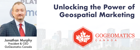
Join us at the Calgary GoGeomatics Expo for an exclusive workshop hosted by Jonathan Murphy, the founder of GoGeomatics and GeoIgnite. In this session, you'll discover the opportunites to successful marketing with GoGeomatics and explore the vibrant world of the GoGeomatics community. Workshop Highlights:Marketing with GoGeomatics: Dive into the art of geospatial marketing with one of the industry's leading experts. Jonathan Murphy will guide yo...

Join us at the GoGeomatics Expo for a dynamic panel discussion on the latest trends in Lidar technology. Our panel of experts will dive into the advancements in Lidar data, hardware, and software, providing valuable insights into the ever-evolving geospatial world. Discover the future of Lidar and its applications, and stay at the forefront of geomatics innovation.lidarcanex.com


As part of Planet’s ethos of ‘agile aerospace’, we continually invest in the latest hardware and software advancements to improve the PlanetScope image quality. This dataset began life as a relatively simple 3-band image using commercial, ‘off-the-shelf’ hardware components. Through customer feedback, both software and hardware improvements were tested and launched, resulting in a second-generation of PlanetScope, or ‘Dove’ satellites. Replacing this second generation of satellites involved a...


Menu - Big Four OutletAppetizersRoasted Diablo Pork Bites (12) (GF/DF) SaladsSpiced Cauliflower, Chickpea & Tofu Bowl (GF/DF/V/VE) Sweet Potato, Roasted Cauliflower, Chickpeas, Mint Chutney,Grilled Tofu, Madras Curry DressingClassi...

Research Presentation:Airborne Topo-Bathymetric Lidar Combined with Thermal Imaging for Fish Habitat Studies in RiversResearchers at Nova Scotia Community College’s Applied Geomatics Research Group have been using the airborne Leica Chiroptera 4X topo-bathymetric lidar sensor for nearly a decade and have surveyed coastal, riverine and lake environments. They have concentrated on mapping submerged aquatic vegetation (SAV). Topo-bathy lidar data of rivers provides an opportu...

CHC Navigation (CHCNAV) is a global provider of innovative GNSS navigation and positioning solutions covering a wide range of professional applications, including land and airborne surveys, conventional GNSS surveys, 3D data acquisition, precision farming, unmanned navigation and robotics, real-time GNSS infrastructure and more.Significant and sustained investments in GNSS software, algorithms and core technology allow us to provide leading-edge technologies that meet the exact needs o...


Join us at the GoGeomatics Expo for an insightful panel discussion that tackles the pressing question: Where will the next generation of land surveyors emerge from? Our panel, featuring experienced educators and professional land surveyors, will engage in a thought-provoking dialogue on strategies and solutions to attract and nurture the future leaders of the land surveying profession. Don't miss this opportunity to gain valuable perspectives on the future of land surveying.