
Steffen Shaigec
Researcher
UWO
Sessions in which Steffen Shaigec attends
10:30 AM
10:30 AM
- Measuring Pandora: can modern geospatial tools and techniques keep up with our changing planet? Big Four Roadhouse - Career Theatre
- 10:30 AM MST - 10:55 AM MST | 25 minutes
- Is change the new normal? Every year seems to be the next warmest year. Those of us looking back at our planet from space are seeing these changes ...


11:30 AM
11:30 AM
- Agile Aerospace for a Changing Planet Big Four Roadhouse - Theatre 3
- 11:30 AM MST - 11:55 AM MST | 25 minutes
- Planet scans the entire land mass of the planet nearly everyday with high resolution multispectral imagery, enabling exciting new opportunities and...
- Talk


- Building a Geospatial Sensor Web for Mitigating Global Climate Change Big Four Roadhouse - Career Theatre
- 11:30 AM MST - 11:55 AM MST | 25 minutes
- Addressing the escalating levels of methane in the Earth's atmosphere is among the most urgent issues humanity faces. Methane ranks as one of the m...
- Talk


- Monitoring Western Canada With MAXAR Technology: The Use of the MAXAR Constellation and WeatherDesk platforms Big Four Roadhouse - Theatre 1
- 11:30 AM MST - 11:55 AM MST | 25 minutes
- MAXAR Technology provides integrated space infrastructure and earth intelligence capabilities that make global change visible, information actionab...

12:00 PM
12:00 PM
- Maximize your operations using a unique Lidar that offers versatility and performance Big Four Roadhouse - Theatre 1
- 12:00 PM MST - 12:25 PM MST | 25 minutes
- In February 2022, Balko Technologies, a Quebec-based company, launched the world's first modular drone Lidar, which aims to democratize geospati...
- Talk


- LiDAR for Post Wildfire Mapping Applications Big Four Roadhouse - Career Theatre
- 12:00 PM MST - 12:25 PM MST | 25 minutes
- LiDAR continues to be a cornerstone of the mapping industry. Since its inception, the technology has evolved from sole use on manned aircraft to be...
- Talk


- New Space: addressing Canada's challenges in wildfire, emissions and natural resource management Big Four Roadhouse - Theatre 2
- 12:00 PM MST - 1:00 PM MST | 1 hour
- In the face of escalating environmental challenges, Canada grapples with the urgent need for advanced solutions in wildfire monitoring, emission...
- Panel


12:30 PM
12:30 PM
- Flood Hazard Mapping Data and Its Importance: Jurisdictional Complexity, Innovation in Data Dissemination, and Advancing Adaptation Big Four Roadhouse - Theatre 3
- 12:30 PM MST - 12:55 PM MST | 25 minutes
- Flooding is Canada’s most costly natural disaster, and flood risk intensifies as a result of urbanization and climate change. These impacts will...
- Talk


1:30 PM
1:30 PM
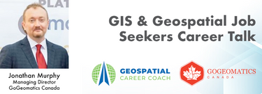
- GIS & Geospatial Job Seekers Career Talk Big Four Roadhouse - Career Theatre
- 1:30 PM MST - 1:50 PM MST | 20 minutes
- This talk focused on those seeking work in GIS, cartography, remote sensing, programming, and other related geospatial...
- Talk

1:45 PM
1:45 PM
- Navigating the Constellation: The Utility of New Earth Observation Satellites Big Four Roadhouse - Theatre 3
- 1:45 PM MST - 2:10 PM MST | 25 minutes
- With an increasing multitude of new Earth Observation (EO) satellites, it is imperative for the geomatics community to assess the fit of these emer...
- Talk


- The Importance of Scientific Quality Data in Applications of Change Detection Big Four Roadhouse - Theatre 1
- 1:45 PM MST - 2:10 PM MST | 25 minutes
- There is a pressing need for a global change detection system capable of persistently monitoring the entire earth with globally consistent ...
- Talk

2:15 PM
2:15 PM
- GIS Solutions Enhancing Emergency Response, Management, and Response Team Assessments Big Four Roadhouse - Theatre 1
- 2:15 PM MST - 2:40 PM MST | 25 minutes
- Incidents involving dangerous goods, including flammable gases and liquids, can happen at any time and in any place. When they do, Emergency Res...
- Talk


4:00 PM
4:00 PM
- Centralized Municipal Imagery Data: Putting power in the hands of the people Big Four Roadhouse - Theatre 3
- 4:00 PM MST - 4:25 PM MST | 25 minutes
- Harnessing the power of regular collection of imagery and Lidar, the City of Calgary provides valuable information for municipal service delivery. ...
- Talk


- New AI Powered Tools to Increase Drone Point Cloud Deliverable Productivity Big Four Roadhouse - Theatre 1
- 4:00 PM MST - 4:25 PM MST | 25 minutes
- Learn how newly implemented surface modeling tools employing artificial intelligence reduce the turnaround time of point cloud surface models by...
- Talk


4:30 PM
4:30 PM
- Expo Reception Party Big Four Roadhouse - Expo Trade Show Floor
- 4:30 PM MST - 7:00 PM MST | 2 hours 30 minutes
- The end of the first day of the National Canadian GoGeomatics Expo is being marked by a lively party that is eagerly anticipated by all participant...
-

10:30 AM
10:30 AM
- Modelling Wetland Vegetation Trajectories using Machine Learning and Multispectral Sentinel-2 Imagery Big Four Roadhouse - Theatre 3
- 10:30 AM MST - 10:55 AM MST | 25 minutes
- Wetlands are important to water quality, nutrient cycling, and biodiversity, and have been identified as a management priority across Canada. Re...
- Talk


12:00 PM
12:00 PM
- Canada’s SLAM Market: Applications & Considerations for Industry Big Four Roadhouse - Theatre 2
- 12:00 PM MST - 1:00 PM MST | 1 hour
- The SLAM Scan-off results are in, but what does that mean, where can this technology be applied, and what technology can be applied to it?Jo...
- Panel


- Multi-band SAR for Earth Observation and MDA's Next Generation Chorus Constellation Big Four Roadhouse - Theatre 3
- 12:00 PM MST - 12:25 PM MST | 25 minutes
- The talk presents how multi-band SARs (X-band Iceye, C-band RADARSAT-2 and L-band SAOCOM) support various earth observation applications, such as t...
- Talk


12:30 PM
12:30 PM
- Establishing an Urban Infrastructure Mapping Research Program Big Four Roadhouse - Theatre 1
- 12:30 PM MST - 12:55 PM MST | 25 minutes
- Geoff Zeiss devoted over 30 years of his life to the Geospatial industry and global community, focusing on utility and construction sectors, and ma...
- Talk


1:45 PM
1:45 PM
- A High-Resolution, Continental Scale, and Modular Flood Risk Estimation Framework Big Four Roadhouse - Theatre 3
- 1:45 PM MST - 2:10 PM MST | 25 minutes
- The lack of up-to-date, easily available flood risk data has slowed down Canadian attempts to mitigate flood damage, notwithstanding the substantia...
- Talk


- Airborne Topo-Bathymetric Lidar Combined with Thermal Imaging for Fish Habitat Studies in Rivers Big Four Roadhouse - Theatre 1
- 1:45 PM MST - 2:10 PM MST | 25 minutes
- Research Presentation:Airborne Topo-Bathymetric Lidar Combined with Thermal Imaging for Fish Habitat Studies in RiversResearchers at ...
- Talk


- Fast Pitches Big Four Roadhouse - Theatre 2
- 1:45 PM MST - 2:45 PM MST | 1 hour
- Got a cool geomatics product, service, student project, or academic/science research project/paper? Pitch it to a select panel of geomatics pres...
-
