Kristopher Kerwin
Elementy, w których Kristopher Kerwin attends
wtorek 14 maja, 2024
Mini Continental BreakfastGeoIgnite is delighted to offer a selection of chilled fruit juices, freshly baked croissants, muffins, and breakfast pastries, served with butter and preserves. Guests can also enjoy fruit cocktails and yogurt. Available beverages include coffee, tea, and decaffeinated coffee.

Connecting the knowledge economy to the emerging relationship economy in a geospatial context. This talk will emphasize the growing importance of social skills and human connectivity in harnessing the power of data and technology. His talk, titled "Human Interoperability: Enhancing Geospatial Effectiveness in the Relationship Economy," explores the notion of valuing existing resources and optimizing the use of data and technology, particularly in the geospatial sector. As the Executive Office...


GeoIgnite is thrilled to present its keynote session, "Canada's Geospatial Leadership Panel," a gathering of some of Canada's most influential figures in the field of geospatial technology in Canada. Panelist: Melanie Desjardins, Director of the NWT Centre for Geomatics, showcases the application of geospatial technology in public sector management and natural resource governance. Her leadership in geomatics plays a significant role in shaping policies and strategies that utilize ...


In today's rapidly advancing technological environment, the imperative for robust digital governance has never been more critical. The rapid increase of digital technologies and data has underscored an necessity for standardized governance frameworks that not only bolster security and trust but also ensure innovation and efficiency across diverse global systems. This presentation will delve into the paramount importance of establishing and adhering to consensus-based standards in ...


Following the definition set out in the United Kingdom by Digital Built Britain, we understand a digital twin to be “...a realistic digital representation of assets, processes or systems in the built or natural environment…that adds social and economic value by augmenting the decision-making process.” Further, this digital representation has the capacity to exchange real time information with its physical twin and to use that information to learn, predict, or enact a possible response to a gi...


This presentation will explore how Sault Ste. Marie leveraged two decades of Geographic Information Systems (GIS) to craft and maintain its cutting-edge Digital Twin. Exploring the innovative applications of Sault Ste. Marie’s GIS digital twin model, which offers real-time insights allowing for collaboration and more effective decision making, this presentation showcases the transformative potential of GIS enabled digital twins. We will demonstrate how this comprehensive digital r...


Monitoring large numbers of activities and assets from space has long been an aspirational “holy grail” for satellite remote sensing. However, lack of observational cadence, collection capacity, sufficient resolution, multisource capabilities and contextual understanding of monitored sites has meant that true monitoring has been limited to a handful of key facilities and mission use cases. Will we as an industry be able to overcome current challenges and turn site monitoring into a mainstream...

Day 1 Lunch Buffet MenuIndulge in a vibrant selection at our buffet, featuring a house blend of baby spinach, kale, and mesclun greens tossed with feta cheese, a custom blend of seeds, dried cranberries, and golden raisins. Savor the exotic flavors of curried couscous with raisins, freshly made...

Public Safety Canada has a mandate to keep Canadians safe from a range of risks, including natural disasters, and has taken recent steps to incorporate the use of data and science into all aspects of Emergency Management. In 2020, Public Safety stood up the Data Science and Engineering Team (DSET) to provide technical expertise and quantitative risk analysis in support of major policy programs, including Flood Insurance, ...


The global OGC community continues to accelerate innovation, based on practical real world demonstrations of the art of possible for connecting and sharing data and information related to climate resiliency for disasters, climate monitoring for terrestrial and marine environments and more. This talk will provide a brief overview of the latest work, with a focus on "what is next?".


In the upcoming Canada's National Geospatial Conference, we are delighted to host a special plenary session, "Mapping the Future: Honoring Geoff Zeiss and His Transformative Work in Geospatial Technology," on May 14th in Ottawa. This session is dedicated to celebrating the remarkable contributions of Geoff Zeiss to the fields of mapping, utilities, and Geographic Information Systems (GIS).Geoff Zeiss, renowned for his insightful blog...


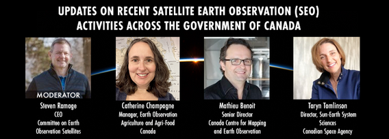
GeoIgnite is excited to present an all star panel discussion on earth observation in Canada. This panel brings together a trifecta of esteemed experts from various Canadian government agencies, with Steven Ramage, CEO of the Committee on Earth Observation Satellites (CEOS), serving as the moderator.Moderator: Steven Ramage, in his role as CEO of CEOS, brings a wealth of knowledge and experience in satellite earth observation. His expertise in coordinating international satellite earth ...


środa 15 maja, 2024

The domains of BIM and GIS have historically been separate areas of expertise and been considered distinct and separate domains. However, the need for geospatial technologies to integrate with Building Information Modeling (BIM) design applications and the need for BIM geometry and data to be applied in Geographic Information Systems (GIS) is becoming more prevalent. In the rapidly evolving period of urban development, BIM and GIS emerge as pivotal technology tools shaping the future of...

Remote sensing and spatial analytics have substantial utility to support riverine and floodplain assessment and monitoring at extents not feasible with traditional field surveys. This presentation will provide an overview of relevant technologies such as topobathymetric lidar, sonar, and multiple imagery types, as well as processes for integrating and analyzing these data. Broad-scale, objective, and reproducible analytics allow for geographic and temporal comparison across entire...


The Department of National Defence, as steward of a real property (RP) portfolio that includes tens of thousands of buildings and supporting infrastructure, is seeking to manage its Real Property (RP) assets more effectively by modernizing and improving its digital capability. In this effort, interoperability between BIM and GIS through open data standards is crucial to enable the Integrated Digital Built Environment. BIM allows representation of detailed information regarding building elemen...


The Applied Geomatics Research Group, a spinoff of COGS at NSCC in 2000 has been conducting applied research using lidar since it’s inception. Originally by contracting lidar providers to conduct surveys in the Maritimes for flood hazard mapping, then in the 2005 operating their our topographic lidar, the Optech ALTM 3100, then moving into the coastal environment with the Leica Chiroptera 4X topo-bathymetric lidar, and most recently moving to the relatively low cost drones for topo-lidar mapp...


The agriculture and agri-food sector is a major contributor to the Canadian economy, accounting for 2.3 millions jobs and 7% of Canada’s gross domestic product with farmland covering 62 million hectares (6.2%) of Canada’s land area. This area is changing over annual and decadal time scales as a result of changes in annual crop production, urban expansion, sustainable land use/management and a changing climate. Monitoring such a vast area to account for how these environments respond to the pr...

Remotely Piloted Aircraft Systems (RPAS), or drones, are becoming more common in the construction industry as a key tool to complete complex building and infrastructure projects. As technology improves, the barriers to adoption are reduced, creating a huge opportunity for the industry to improve the construction process and support the ongoing digital transformation. Drones boost productivity by enabling construction teams to rapidly and easily survey job sites, track progress, and spot poten...


Climate change presents an array of unprecedented challenges to global resilience and sustainability. As the urgency to address these challenges increases, the role of geomatics as a cornerstone technology for enabling climate resilience becomes ever more significant. This panel discussion, moderated by Tanya Harrison of the Earth & Planetary Institute of Canada, will explore the transformative potential of geomatics in bolstering climate resilience.


Global urban expansion is rapidly increasing, with over 50% currently living in cities and an expected rise to 66% by 2050. This growth poses challenges for peri-urban areas, including agricultural land loss, biodiversity destruction, and climate change impacts. Comprehensive research, integrating urban and rural perspectives, is vital, emphasizing the need for quantitative methods like the model analysis approach. The complexity of urban systems, inspired by ecological theories, requires geo...