
Neil Thompson
Sessions in which Neil Thompson attends
Tuesday 14 May, 2024
Mini Continental BreakfastGeoIgnite is delighted to offer a selection of chilled fruit juices, freshly baked croissants, muffins, and breakfast pastries, served with butter and preserves. Guests can also enjoy fruit cocktails and yogurt. Available beverages include coffee, tea, and decaffeinated coffee.

Connecting the knowledge economy to the emerging relationship economy in a geospatial context. This talk will emphasize the growing importance of social skills and human connectivity in harnessing the power of data and technology. His talk, titled "Human Interoperability: Enhancing Geospatial Effectiveness in the Relationship Economy," explores the notion of valuing existing resources and optimizing the use of data and technology, particularly in the geospatial sector. As the Executive Office...

GeoIgnite is thrilled to present its keynote session, "Canada's Geospatial Leadership Panel," a gathering of some of Canada's most influential figures in the field of geospatial technology in Canada. Panelist: Melanie Desjardins, Director of the NWT Centre for Geomatics, showcases the application of geospatial technology in public sector management and natural resource governance. Her leadership in geomatics plays a significant role in shaping policies and strategies that utilize ...


In today's rapidly advancing technological environment, the imperative for robust digital governance has never been more critical. The rapid increase of digital technologies and data has underscored an necessity for standardized governance frameworks that not only bolster security and trust but also ensure innovation and efficiency across diverse global systems. This presentation will delve into the paramount importance of establishing and adhering to consensus-based standards in ...


We will have a Government of Canada science Director speaking about careers: Andrew Davidson, a scientist with the Canadian Government, will talk about his experiences negotiating the minefield that can be the Government hiring process, and the things you need to do when applying for that Government job. Have you ever applied for a job with the Government of Canada and wondered why you weren't considered for...

Following the definition set out in the United Kingdom by Digital Built Britain, we understand a digital twin to be “...a realistic digital representation of assets, processes or systems in the built or natural environment…that adds social and economic value by augmenting the decision-making process.” Further, this digital representation has the capacity to exchange real time information with its physical twin and to use that information to learn, predict, or enact a possible response to a gi...


This presentation will explore how Sault Ste. Marie leveraged two decades of Geographic Information Systems (GIS) to craft and maintain its cutting-edge Digital Twin. Exploring the innovative applications of Sault Ste. Marie’s GIS digital twin model, which offers real-time insights allowing for collaboration and more effective decision making, this presentation showcases the transformative potential of GIS enabled digital twins. We will demonstrate how this comprehensive digital r...


This presentation delves into the dynamic realm of geomatics within Environment and Climate Change Canada (ECCC), offering a comprehensive exploration of career opportunities within a research organization. Geomatics, the science of acquiring, analyzing, and interpreting geographic information, plays a pivotal role in the mandate of the Department including environmental conservation and protection, policy & regulatory development, and climate change mitigation strategies.Through t...

Monitoring large numbers of activities and assets from space has long been an aspirational “holy grail” for satellite remote sensing. However, lack of observational cadence, collection capacity, sufficient resolution, multisource capabilities and contextual understanding of monitored sites has meant that true monitoring has been limited to a handful of key facilities and mission use cases. Will we as an industry be able to overcome current challenges and turn site monitoring into a mainstream...

Day 1 Lunch Buffet MenuIndulge in a vibrant selection at our buffet, featuring a house blend of baby spinach, kale, and mesclun greens tossed with feta cheese, a custom blend of seeds, dried cranberries, and golden raisins. Savor the exotic flavors of curried couscous with raisins, freshly made...


The global OGC community continues to accelerate innovation, based on practical real world demonstrations of the art of possible for connecting and sharing data and information related to climate resiliency for disasters, climate monitoring for terrestrial and marine environments and more. This talk will provide a brief overview of the latest work, with a focus on "what is next?".


In the upcoming Canada's National Geospatial Conference, we are delighted to host a special plenary session, "Mapping the Future: Honoring Geoff Zeiss and His Transformative Work in Geospatial Technology," on May 14th in Ottawa. This session is dedicated to celebrating the remarkable contributions of Geoff Zeiss to the fields of mapping, utilities, and Geographic Information Systems (GIS).Geoff Zeiss, renowned for his insightful blog...


After a description of the Canadian Space Agency (CSA)'s mandate and mission, an overview of the different sectors in the Canadian Space Agency that touch on geomatics, is given. Different roles are described and the relationships with external entities as part of these roles. Examples of profiles of people at CSA are given.

The Spatial Data Services Program at DCC is an integrated, collaborative partnership with DND’s Real Property Spatial Data group (ADM(IE), DAES/DRPS). We provide innovative data support throughout the real property asset lifecycle and play a key role in helping DND adopt cutting-edge technology and processes to sustainably manage their portfolio. We are eager to develop capacity and encourage careers in this industry by recruiting practitioners with cross-functional skill sets and knowledge o...

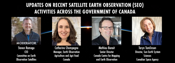
GeoIgnite is excited to present an all star panel discussion on earth observation in Canada. This panel brings together a trifecta of esteemed experts from various Canadian government agencies, with Steven Ramage, CEO of the Committee on Earth Observation Satellites (CEOS), serving as the moderator.Moderator: Steven Ramage, in his role as CEO of CEOS, brings a wealth of knowledge and experience in satellite earth observation. His expertise in coordinating international satellite earth ...


Get ready to mix, mingle, and enjoy an evening of delightful tastes and entertainment at the GeoIgnite Conference Social.Your conference registration includes a delectable assortment of culinary offerings prepared by the head chef of the OEC. Indulge in a variety of hot canapés, including Vegetable Spring Rolls, Spanakopita, Chicken Skewer and Lamb Spiedini. Our cold selection features Cucumber with Dill Cream Cheese and Shrimps, Bri...
Wednesday 15 May, 2024

Mini Continental BreakfastGeoIgnite is delighted to offer a selection of chilled fruit juices, freshly baked croissants, muffins, and breakfast pastries, served with butter and preserves. Guests can also enjoy fruit cocktails and yogurt. Available beverages include coffee, tea, and decaffeinated coffee.

GeoIgnite is excited to present a high-profile panel discussion, "Navigating New Frontiers: The Role of Geospatial AI in Shaping Our World." This session brings together three influential leaders in the field: Bilyana Anicic, President of Aurora Consulting, Jon Lipinski, Co-Founder and President of Ecopia Tech; Abe Tarapani, CEO of Atlas AI; and Will Cadell, CEO of Sparkgeo.Bilyana Anicic, President of Aurora Consulting and the architect of the Federal Geosp...


The Carleton University Immersive Media Studio (CIMS) was awarded a New Frontiers in Research Fund (NFRF) Exploration program grant to Imagine Canada’s Digital Twin. One aspect of the project is data governance and business models. In addition, the I Trust AI research SSHRC funded project based out of UBC, is examining the CIMS and city of Ottawa Digital Twins to assess how their creators might include preservation in their design. These research projects revealed that the Architecture, Engin...


The Department of National Defence, as steward of a real property (RP) portfolio that includes tens of thousands of buildings and supporting infrastructure, is seeking to manage its Real Property (RP) assets more effectively by modernizing and improving its digital capability. In this effort, interoperability between BIM and GIS through open data standards is crucial to enable the Integrated Digital Built Environment. BIM allows representation of detailed information regarding building elemen...


The agriculture and agri-food sector is a major contributor to the Canadian economy, accounting for 2.3 millions jobs and 7% of Canada’s gross domestic product with farmland covering 62 million hectares (6.2%) of Canada’s land area. This area is changing over annual and decadal time scales as a result of changes in annual crop production, urban expansion, sustainable land use/management and a changing climate. Monitoring such a vast area to account for how these environments respond to the pr...
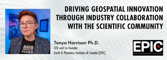
The Earth observation (EO) sector has struggled to break outside its own space echo chamber to have its full potential realised for both social and economic benefit. Can better collaboration between industry and the scientific community help to unlock this potential and drive geospatial innovation? Dr. Tanya Harrison, Co-Founder and CEO of the Earth and Planetary Institute of Canada (EPIC), will highlight examples of such collaborations that have led to breakthroughs that enhanced both indust...


Day 2 Day Lunch Buffet MenuOn the final day of GeoIgnite, enjoy an exquisite lunch buffet featuring artisanal garlic focaccia and a classic Caesar salad, with croutons and bacon bits served on the side. Relish a medley of olives and marinated mushrooms. Savor lightly breaded chicken breast glazed in a tomato and basil sauce, topped with ...

Climate change presents an array of unprecedented challenges to global resilience and sustainability. As the urgency to address these challenges increases, the role of geomatics as a cornerstone technology for enabling climate resilience becomes ever more significant. This panel discussion, moderated by Tanya Harrison of the Earth & Planetary Institute of Canada, will explore the transformative potential of geomatics in bolstering climate resilience.


The presentation will be focused on the deployment of technological processes on the Centre Block Rehabilitation project and illustrate how the team is managing and manipulating different forms of asset element data for distribution and coordination among an exceptionally large subset of stakeholders, each with their own complex set of requirements and governance policies. Several technologies have been developed and employed to consolidate data from multiple sources so that current and futur...

