
Lars T
Elementy, w których Lars T attends
wtorek 14 maj, 2024

GeoIgnite is thrilled to present its keynote session, "Canada's Geospatial Leadership Panel," a gathering of some of Canada's most influential figures in the field of geospatial technology in Canada. Panelist: Melanie Desjardins, Director of the NWT Centre for Geomatics, showcases the application of geospatial technology in public sector management and natural resource governance. Her leadership in geomatics plays a significant role in shaping policies and strategies that utilize ...


Join Priya Aduvala, Recruitment Lead at Altis Technology, for a dynamic session focused on the geomatics sector's role in today’s dynamic job market, and the growing demand for these specialized skills. Priya will share her expert insights from her extensive interactions with industry clients, including the top skills hiring managers are looking for, the wide range of positions available at all levels, the prerequisites for roles involving security clearances, and the flexibilit...


We will have a Government of Canada science Director speaking about careers: Andrew Davidson, a scientist with the Canadian Government, will talk about his experiences negotiating the minefield that can be the Government hiring process, and the things you need to do when applying for that Government job. Have you ever applied for a job with the Government of Canada and wondered why you weren't considered for...

This presentation delves into the dynamic realm of geomatics within Environment and Climate Change Canada (ECCC), offering a comprehensive exploration of career opportunities within a research organization. Geomatics, the science of acquiring, analyzing, and interpreting geographic information, plays a pivotal role in the mandate of the Department including environmental conservation and protection, policy & regulatory development, and climate change mitigation strategies.Through t...

Monitoring large numbers of activities and assets from space has long been an aspirational “holy grail” for satellite remote sensing. However, lack of observational cadence, collection capacity, sufficient resolution, multisource capabilities and contextual understanding of monitored sites has meant that true monitoring has been limited to a handful of key facilities and mission use cases. Will we as an industry be able to overcome current challenges and turn site monitoring into a mainstream...


Public Safety Canada has a mandate to keep Canadians safe from a range of risks, including natural disasters, and has taken recent steps to incorporate the use of data and science into all aspects of Emergency Management. In 2020, Public Safety stood up the Data Science and Engineering Team (DSET) to provide technical expertise and quantitative risk analysis in support of major policy programs, including Flood Insurance, ...


The global OGC community continues to accelerate innovation, based on practical real world demonstrations of the art of possible for connecting and sharing data and information related to climate resiliency for disasters, climate monitoring for terrestrial and marine environments and more. This talk will provide a brief overview of the latest work, with a focus on "what is next?".


After a description of the Canadian Space Agency (CSA)'s mandate and mission, an overview of the different sectors in the Canadian Space Agency that touch on geomatics, is given. Different roles are described and the relationships with external entities as part of these roles. Examples of profiles of people at CSA are given.

Join us at GeoIgnite 2024 for a dynamic career panel featuring a distinguished lineup of leaders from government and industry, who will explore the evolving landscape of geospatial careers in Canada. This panel, moderated by Susan Kasumba, Director of Business Development at Airborne Imaging Inc., will provide invaluable insights into the current and future trends shaping the geospatial sector.Panelists include Melanie Desjardins, Di...


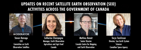
GeoIgnite is excited to present an all star panel discussion on earth observation in Canada. This panel brings together a trifecta of esteemed experts from various Canadian government agencies, with Steven Ramage, CEO of the Committee on Earth Observation Satellites (CEOS), serving as the moderator.Moderator: Steven Ramage, in his role as CEO of CEOS, brings a wealth of knowledge and experience in satellite earth observation. His expertise in coordinating international satellite earth ...


środa 15 maj, 2024

GeoIgnite is excited to present a high-profile panel discussion, "Navigating New Frontiers: The Role of Geospatial AI in Shaping Our World." This session brings together three influential leaders in the field: Bilyana Anicic, President of Aurora Consulting, Jon Lipinski, Co-Founder and President of Ecopia Tech; Abe Tarapani, CEO of Atlas AI; and Will Cadell, CEO of Sparkgeo.Bilyana Anicic, President of Aurora Consulting and the architect of the Federal Geosp...


As evidenced by the 2023 fire season, we are experiencing unprecedented fire management challenges in Canada. Innovative fire monitoring solutions can help support wildfire managers as they limit the negative impacts of wildland fires while also prioritize the positive benefits in Canada’s forested ecosystems. Opportunities for advancing fire monitoring mirror a broader paradigm shift in the field of Earth observations towards open data, large-scale analyses, and collaborative development. In...

Remote sensing and spatial analytics have substantial utility to support riverine and floodplain assessment and monitoring at extents not feasible with traditional field surveys. This presentation will provide an overview of relevant technologies such as topobathymetric lidar, sonar, and multiple imagery types, as well as processes for integrating and analyzing these data. Broad-scale, objective, and reproducible analytics allow for geographic and temporal comparison across entire...


Within its highly dynamic environment, Geospatial Leaders need to integrate knowledge, knowhow, and leadership skills to promote and fully enable this domain while communicating their value proposition to decision makers. This talk will introduce a Framework for leadership development to assist Geospatial Leaders to optimize their success as leaders a...


Remotely Piloted Aircraft Systems (RPAS), or drones, are becoming more common in the construction industry as a key tool to complete complex building and infrastructure projects. As technology improves, the barriers to adoption are reduced, creating a huge opportunity for the industry to improve the construction process and support the ongoing digital transformation. Drones boost productivity by enabling construction teams to rapidly and easily survey job sites, track progress, and spot poten...


Climate change presents an array of unprecedented challenges to global resilience and sustainability. As the urgency to address these challenges increases, the role of geomatics as a cornerstone technology for enabling climate resilience becomes ever more significant. This panel discussion, moderated by Tanya Harrison of the Earth & Planetary Institute of Canada, will explore the transformative potential of geomatics in bolstering climate resilience.


Canada is big, really big! Mapping the whole country took us over 100 years to complete. Through the years, the techniques used to map Canada's features evolved.For NRCan, the latest innovation is in the operational implementation of Artificial Intelligence tools and approaches, nested in high performance cloud computing capacity, and build via micros-ervices for agile and scalable deployment. This capacity, enables the organization to increase exponentially its capacity to create and ...