
Rachelle Siwy
GIS Analyst
Colliers
Sessions in which Rachelle Siwy attends
9:00 AM
9:00 AM
- GoGeomatics Expo Poster Program
- Tue 7, 09:00 AM MST - Wed 8, 04:00 PM MST | 1 day 7 hours
- Student posters will be available for viewing in the Expo Gall...
-

9:45 AM
9:45 AM
- Welcome Big Four Roadhouse
- 9:45 AM MST - 10:00 AM MST | 15 minutes
- Talk


10:00 AM
10:00 AM
- Evolving Reality Capture Panel Big Four Roadhouse - Theatre 2
- 10:00 AM MST - 10:45 AM MST | 45 minutes
- Join us for a riveting panel discussion featuring leading experts in the realm of reality capture. As the industry stands on the precipice of mo...
- Panel


11:00 AM
11:00 AM
- Navigating The Digital Geospatial Revolution at Suncor Big Four Roadhouse - Theatre 3
- 11:00 AM MST - 11:25 AM MST | 25 minutes
- Over his decade plus at Suncor, Alonzo has been both witness to and active participant in a quiet digital Geospatial revolution. This revolution ha...
- Talk


12:00 PM
12:00 PM
- LiDAR for Post Wildfire Mapping Applications Big Four Roadhouse - Career Theatre
- 12:00 PM MST - 12:25 PM MST | 25 minutes
- LiDAR continues to be a cornerstone of the mapping industry. Since its inception, the technology has evolved from sole use on manned aircraft to be...
- Talk

12:30 PM
12:30 PM
- Flood Hazard Mapping Data and Its Importance: Jurisdictional Complexity, Innovation in Data Dissemination, and Advancing Adaptation Big Four Roadhouse - Theatre 3
- 12:30 PM MST - 12:55 PM MST | 25 minutes
- Flooding is Canada’s most costly natural disaster, and flood risk intensifies as a result of urbanization and climate change. These impacts will...
- Talk


1:00 PM
1:00 PM
- Lunch Break Big Four Roadhouse
- 1:00 PM MST - 1:45 PM MST | 45 minutes
- Menu - Big Four OutletAppetizers
-
2:45 PM
2:45 PM
- buildingSMART BIM/GIS Panel Big Four Roadhouse - Theatre 2
- 2:45 PM MST - 3:30 PM MST | 45 minutes
- Join us at the BIM/GIS panel of our conference as we delve into critical subjects shaping the intersection of Building ...
- Panel


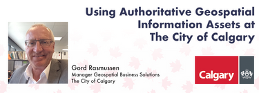
- Using Authoritative Geospatial Information Assets at The City of Calgary Big Four Roadhouse - Theatre 1
- 2:45 PM MST - 3:10 PM MST | 25 minutes
- Creating, managing and sharing geospatial information has never been easier, but how do we ensure the information we are using to make key business...
- Talk

3:30 PM
3:30 PM
- Unlocking the Power of GIS in Facility Management: An Introduction to VertiGIS FM Big Four Roadhouse - Theatre 3
- 3:30 PM MST - 3:55 PM MST | 25 minutes
- As GIS professionals, we understand the pivotal role that geospatial data plays in decision-making across various industries. Now, imagine harnessi...
- Talk


4:00 PM
4:00 PM
- Centralized Municipal Imagery Data: Putting power in the hands of the people Big Four Roadhouse - Theatre 3
- 4:00 PM MST - 4:25 PM MST | 25 minutes
- Harnessing the power of regular collection of imagery and Lidar, the City of Calgary provides valuable information for municipal service delivery. ...
- Talk


10:00 AM
10:00 AM
- Lidar CANEX Panel Big Four Roadhouse - Theatre 2
- 10:00 AM MST - 10:45 AM MST | 45 minutes
- Join us at the GoGeomatics Expo for a dynamic panel discussion on the latest trends in Lidar technology. Our panel of experts will dive into the ad...
- Panel
-
 LidarCanex 2024Sponsor


10:30 AM
10:30 AM
- Modelling Wetland Vegetation Trajectories using Machine Learning and Multispectral Sentinel-2 Imagery Big Four Roadhouse - Theatre 3
- 10:30 AM MST - 10:55 AM MST | 25 minutes
- Wetlands are important to water quality, nutrient cycling, and biodiversity, and have been identified as a management priority across Canada. Re...
- Talk


11:00 AM
11:00 AM
- SLAM Scan-Off Results Big Four Roadhouse - Theatre 2
- 11:00 AM MST - 12:00 PM MST | 1 hour
- Rapid, short-range data collection will only become more critical as the technological revolution continues. From planning and analytics to VDC ...
- Talk

12:30 PM
12:30 PM
- Establishing an Urban Infrastructure Mapping Research Program Big Four Roadhouse - Theatre 1
- 12:30 PM MST - 12:55 PM MST | 25 minutes
- Geoff Zeiss devoted over 30 years of his life to the Geospatial industry and global community, focusing on utility and construction sectors, and ma...
- Talk


1:45 PM
1:45 PM
- A High-Resolution, Continental Scale, and Modular Flood Risk Estimation Framework Big Four Roadhouse - Theatre 3
- 1:45 PM MST - 2:10 PM MST | 25 minutes
- The lack of up-to-date, easily available flood risk data has slowed down Canadian attempts to mitigate flood damage, notwithstanding the substantia...
- Talk


2:15 PM
2:15 PM
- Integration of BIM / GIS to achieve the digital built environment for the Department of National Defence Big Four Roadhouse - Theatre 1
- 2:15 PM MST - 2:40 PM MST | 25 minutes
- The Department of National Defence, as steward of a real property (RP) portfolio that includes tens of thousands of buildings and supporting infras...
- Talk
