Monday 28 October, 2024


In this virtual workshop, you will fine-tune a pretrained model from the ArcGIS Living Atlas of the World collection and apply it to high-resolution imagery to efficiently detect and classify objects in ArcGIS Pro. Participants will gain hands-on experience in adjusting the deep learning model parameters to enhance its accuracy and performance for specific use cases. Additionally, you will learn advanced techniques for data preprocessing, prepare training samples, and model evaluation, ensuri...


Arc Hydro is a community, data model, set of tools, and workflows to support the GIS side of hydrologic and hydraulic (H&H) analyses. Learn how to apply the Arc Hydro data model while running workflow-driven tools in a watershed modelling application. Starting with a good quality digital elevation model (DEM), you will conduct terrain preprocessing to hydrologically condition the DEM. The next step will involve input into stream drainage network identification, followed by catchment delin...

We are excited to announce that the next Canada Forum will be held during the GoGeomatics Expo in Calgary, from October 28th to 30th. This event will bring together key stakeholders from across Canada’s geospatial sector, including industry leaders, academics, indigenous communities, government representatives, and technologists, to continue vital discussions on advancing geospatial standards, interoperability, and spatial data infrastructure (SDI) in Canada.


We are excited to announce that the next Canada Forum will be held during the GoGeomatics Expo in Calgary, from October 28th to 30th. This event will bring together key stakeholders from across Canada’s geospatial sector, including industry leaders, academics, indigenous communities, government representatives, and technologists, to continue vital discussions on advancing geospatial standards, interoperability, and spatial data infrastructure (SDI) in Canada.

GoGeomatics is hosting a pizza party for the volunteers setting up the Canada Maps and Poster Gallery at the National Geomatics Expo. It's a chance to enjoy some great food while connecting with fellow volunteers. After the event, you'll also have the opportunity to meet and mingle with exhibitors and speakers, providing a relaxed environment to network with industry professionals before the expo kicks off. Join us for a fun and rewarding eve...

Join us at the National Geomatics Networking Reception Enjoy a selection of gourmet hors d'oeuvres, including savoury Moroccan lamb meatballs, smoked pork belly lollipops, and wild mushroom arancini with truffle oil. Vegetarian options like vegetable samosas with mango chutney and goat cheese tartelettes will satisfy all palates. Plus, your ticket includes a drink to enjoy while you connect with industry professionals. Elevate your evening with these delicious bites and great company!<...


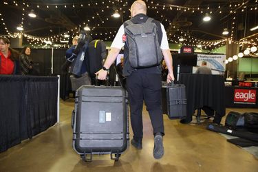
We’re excited to host a special White Hat Ceremony during the Eagle Engineering & Consulting Networking Reception on October 28th at 5:30 PM. This iconic Calgary tradition celebrates the spirit of Western hospitality, welcoming our guests in a unique and memorable way. Be sure to join us as we honor our esteemed supporters from around the world with this special ceremony at the National Geomatics Expo!
Tuesday 29 October, 2024


This career fair is an excellent opportunity for your organization to showcase its vision, culture, and the exciting opportunities on offer. Engage with a diverse pool of candidates, including experienced professionals and emerging talents with fresh perspectives. Each candidate brings unique skills and innovative ideas, making your participation a strategic investment in the future of your organization and the geomatics sector.The Western Canada GeoIgnite Career Fair is crucial for re...


We are hosting a special gallery of maps and posters for this year’s expo.The Canada Maps & Poster Gallery will run from October 29th to the 30th in Calgary and is an excellent opportunity to showcase your team's work and impact for the public good.This initiative is in partnership with the Canadian Cartographic Association (CCA), the Inter...


We explore the motivations behind the implementation of openBIM and its integral role in advancing the built asset industry. The built environment is immense and complex, it is also a huge responsibility. Our industry directly impacts it, designing, creating and maintaining it. In an era where what we all need is a better built environment, openBIM stands out as a key enabler. Together we will imagine a future where our industry works more effectively, efficiently and with more c...


Space, the final frontier. Or is it? Although many people are fascinated by space, most are relatively unaware of how space technologies pervade their everyday life. From global positioning systems (GPS) and satellite communications to weather forecasting and monitoring the health of crops or the extent of sea ice, the standard of living we currently enjoy is fundamentally dependent on satellites and space technology. Space is becoming even more important in monitoring the changing climate, p...


The new Canadian Hydrospatial Network (CHN) is set to replace the National Hydrographic Network (NHN) for Canada. Designed for improved use in hydrological models, the CHN is analysis ready with full-network traversing ability, and value-added attributes such as stream order. The CHN is also created from higher-resolution source data and better aligned to elevation than the NHN, where possible, and has been streamlined for production and maintenance.Work is on-going to refine methods a...


Got a great idea, paper, project or product? Here’s an opportunity to hone your skills in making a “fast pitch”. There’s and art to making a fast pitch, where less can be more.The GoGeomatics Expo in 2023 launched the Fast Pitch session. Modelled after the Pitch-the-Press session of GeoWeek, presenters have 3 minutes to make your best case, followed by 2 minutes of questions from a panel and the audience. The panel of geo-journalists and industry experts judge th...


Building Information Modeling (BIM) is transforming the built asset industry, yet firms of varying sizes—large, medium, and small—adopt BIM in distinct ways tailored to their unique resources and project demands. This session will explore BIM’s origins, current applications, and future directions as shared by representatives from three different firms. A significant focus will be on the importance of data integrity and governance, particularly as Artificial Intelligence (AI) becomes increasin...


The Alberta Biodiversity Monitoring Institute (ABMI) defines human footprint as the visible alteration or conversion of native ecosystems to temporary or permanent residential, recreational, agricultural, or industrial landscapes. It also includes land that is periodically reset to earlier successional conditions by industrial activities such as forestry harvest areas and seismic lines. To monitor and map human footprint across Alberta, the ABMI, in partnership with the Alberta Human Footprin...


Subsea acoustic sensors, including multibeam sonars and sub bottom profilers, provide users with a variety of data types to improve our understanding of the marine environment and effectively manage important resources. This includes bathymetry, which is a foundational layer for analysis, but also information on the bottom reflectivity to characterize sediment types, water column data to map mid-water material and organisims by providing a view from the sensor to the floor of our rivers and l...


How exactly does artificial intelligence work and what can you use it for in the geomatics domain? Using real-life examples from our projects, they demonstrate how you can use AI to gain new insights and increase efficiency by automating your data processing workflows.We explore how GeoAI is fusing spatial data science and Geomatics technology to help automate the extraction, classification, and analysis of all types of spatial or non-spatial data. Learn how GeoAI can detect clusters, ...


Sessions: Human footprint datasets for Canada: mapping and monitoring in support of land and resource managementDisturbance is a key component of boreal-forest ecosystems, impacting their structure and functions. In Alberta, disturbances are both natural and anthropogenic, including > 30,000 sqkm of harvest areas. The recovery of all types of forest disturbance influences not only local landscapes, but also carbon dynamics and biodiversity. In the face of a changing climate, the imp...


From ancient cave drawings depicting hunting grounds to hand-sketched layouts of backyard gardens, humans conceptualize space through map making. Maps serve both to capture what exists on the landscape and to plan future uses by intentionally defining where specific activities can happen. Modern satellite technology creates geospatial datasets that can contribute to current and proposed land use management planning, all underpinned by the pursuit of the public good.Background


Menu - Big Four OutletAppetizersRoasted Diablo Pork Bites (12) (GF/DF) SaladsSpiced Cauliflower, Chickpea & Tofu Bowl (GF/DF/V/VE) Sweet Potato, Roasted Cauliflower, Chickpeas, Mint Chutney,Grilled Tofu, Madras Curry DressingClassi...

The session will focus on considerations for deploying Artificial Intelligence in professional practice; identifying potential landmines and working on solutions from a privacy-first perspective. The talk will include a high-level overview that underscores the fundamental components that encapsulate an AI derived “solution” and delve into a practical, real-world example being tested on an active project.Topics Covered:• An illustrated example of BIM model query using AI• AI too...


Maintaining undisturbed habitat is key to the recovery strategy of the Woodland Caribou boreal population. Seismic lines have been identified as a human footprint feature that requires specific attention for habitat restoration in part because linear features are linked to increases in the predation rates of caribou as they provide lines of sight and easy transportation routes for predators. It is estimated that there are hundreds of thousands of kilometers of seismic lines within Alberta (AB...


Too often, when discussing the value proposition of geospatial data, we focus in on raw data or output products without spending a lot of time in the juicy middle of data throughputs. That is to say that modern geospatial is leaving a lot of value on the table and thus limiting our ability to good with our data by: -> Focusing too heavily on the capturing aspect of geospatial technologies;-> Ignoring or discounting analytical capabilities of geospatial technologie...


Water is one of our most vital resources, and its management is becoming increasingly complex in the face of climate change, population growth, and competing demands from agriculture, industry, and municipalities. This panel will delve into how geospatial technologies are revolutionizing water policy by providing the data-driven insights needed for smarter decision-making.Join leading experts from academia, provincial and federal gov...


Accurate mapping of road networks is essential for navigation, disaster response, and urban planning. Traditional methods relying on remote sensing images, Lidar data, and GPS trajectories are hampered by time-consuming manual updates and incomplete extraction due to obstructions from trees, buildings, and shadows. However, recent advancements in deep learning models have shown promise in improving road mapping and automating the detection of missing roads.This study uses a transfer le...

Large-scale habitat inventories are necessary for understanding how human land-use, natural disturbances (e.g., fire) and climate change are influencing ecological processes, species declines and how restoration can address these changes. Within the boreal forest of Alberta, Canada anthropogenic habitat alteration, also referred to as human footprint or the physical disturbance of a landscape as a result of human activity, covers over 19% of the land area. Much of this human footprint is not ...


Session Human footprint datasets for Canada: mapping and monitoring in support of land and resource managementHuman activities have disturbed biodiversity, ecosystems, and ecological processes over the last century. Given the growing trends of habitat loss and biodiversity decline, understanding patterns of human pressures has become a crucial element of conservation planning. In this context, cumulative pressure mapping is used to quantify the extent and intensity of multiple pressure...


Construction contracts are the same worldwide. While there are differences in language, classification, project delivery and other factors, the one common denominator is that a construction contract requires Drawings and Specifications. While geometric modelling software and specification software have both evolved over time, very little effort is currently being exerted in Canada to integrate them in document development processes.According to Arcadis global surveys, the #1 cause of c...


Regional and provincial conservation efforts require detailed human pressure mapping to manage and mitigate human impacts effectively. However, in the province of British Columbia (BC), existing efforts to map human pressures have faced significant challenges, particularly in adequately capturing their full extent. The Geospatial Centre of Biodiversity Pathways at the University of Northern British Columbia, in collaboration with the West Moberly First Nations and the Alberta Biodiversity Mon...


The environmental industry has witnessed a significant transformation in recent years, driven by the adoption of advanced positioning technologies. Geomatics positioning tools have emerged as a pivotal component in this paradigm shift, offering unparalleled precision, efficiency, and accuracy in environmental monitoring, management and remediation projects. ProDelta Projects has been an early adopter and developer of these tools including Field DMS, Smart Dig, R20 and through our Minimal dist...


In 2021, the Government of Canada invested $63.8M in the Flood Hazard Identification and Mapping Program (FHIMP) to to create and disseminate engineering-level flood hazard maps that can help Canadians better plan and prepare for future flood risks. The program was recently extended to 2028 through the National Adaptation Strategy and enhanced with an additional $164 Million investment.Given that many Canadians are unaware of flood hazards, the FHIMP is working to fill gaps in knowledg...


Menu - Big Four OutletAppetizersRoasted Diablo Pork Bites (12) (GF/DF) SaladsSpiced Cauliflower, Chickpea & Tofu Bowl (GF/DF/V/VE) Sweet Potato, Roasted Cauliflower, Chickpeas, Mint Chutney,Grilled Tofu, Madras Curry DressingClassi...

30 years ago, a small group of engineers came together to work on the then difficult problem of interoperable technology, systems and data. These visionaries formed the Open Geospatial Consortium which has helped the world figure out how to collect, process, and share geospatial data over the internet and across a wide variety of technology systems. Today, with the proliferation of technology types, sensors and a...

The health of the global ocean environment is of critical importance. Planetary limits for climate change and biodiversity are being reached, and unsustainable resource management practices are rampant. Space-based Maritime Monitoring has proven to provide foundational support for sustainable management of ocean resources. In the Keynote, John will provide a high-level overview of ocean problems, space-based maritime monitoring, the beneficiaries and outcomes of the application of...


The government of Alberta manages the production of riverine flood studies under the provincial Flood Hazard Identification Program, to assist communities in keeping Albertans safe and protecting their properties from floods. Flood maps improve public safety, support emergency management, and help us build safer and more resilient communities. The government of Alberta also manages the production of alluvial fan studies to help Albertans learn about flood risks in the steep terrain of Alberta...


For the last five years I have been providing reality capture services to documentary film producers. These series have included NatGeo's Buried Secrets of WWII, NatGeo's Drain the Oceans, Discovery's Expedition Unknown and Expedition Bigfoot. LiDAR, photogrammetry, thermography, magnetometry, and multi spectral imagine all provide context that professional storytellers (TV producers) crave. Join me as I share stories, successes, and failures of these unique service offerings.


The First Peoples Innovation Centre (FPIC) plays a significant role in empowering Indigenous communities. The Centre has adapted the FabLab (Fabrication Laboratory) model developed by the Massachusetts Institute of Technology (MIT) with a culturally appropriate response to Indigenous youth, enabling them to take charge of their professional future. The FPIC, incorporating the FabLab Onaki, is pivotal in this empowerment process, as it funds and partners with various organizations to create co...


The Riparian Web Portal (www.riparian.info) is an award-winning project, launched in 2021 by Alberta’s watershed community. This dynamic online space empowers Albertans to enhance riparian health through interactive access to comprehensive data and resources. It serves a crucial role in advancing the riparian health objectives pursued by various watershed groups.At its core, the portal integrates innovative GIS-based assessments from six watershed agencies, covering over 60,000 km of r...


The three building blocks of digital building delivery are BIM, VDC and Digital Twins. There are various definitions for these three things, but based on my experience I define them as follows:- Building Information Modelling: a model with or without 3D geometry that hosts the information about building material, dimensions, connections, forces, power, flow rates, and all other elements required in each element that forms the building. - A key subset of understanding BIM is under...


In flood mapping and dam breach analysis, engineers and planners define inundation areas through flow modeling. A crucial input for this analysis is a comprehensive topographic surface of the area of interest and any upstream zones. These areas can span hundreds of kilometers and cover thousands of square kilometers.Previous studies have indicated that low-resolution topography can results in larger inundation areas, greater flow volumes, and faster flood streams. However, a comparison...


The integration of AI in infrastructure modeling has the potential to revolutionize decision-making processes by providing accurate predictions, identifying vulnerabilities, and optimizing resource utilization.The increasing complexity of modern infrastructure systems, coupled with growing demands on utilities, has necessitated the adoption of advanced analytical techniques. This panel discussion brings together ideas from acad...


Menu - Big Four OutletAppetizersRoasted Diablo Pork Bites (12) (GF/DF) SaladsSpiced Cauliflower, Chickpea & Tofu Bowl (GF/DF/V/VE) Sweet Potato, Roasted Cauliflower, Chickpeas, Mint Chutney,Grilled Tofu, Madras Curry DressingClassi...

Despite the rhetoric surrounding the use of building information modelling (BIM) to enhance collaboration by connecting people and data, the status quo is to work with proprietary solutions and closed file formats, limiting accessibility and interoperability. Additionally, the increasing complexity of projects in the Architecture, Engineering, Construction, and Operations (AECO) industry requires technology that integrates data at a range of scales, from asset to city, and beyond. To address ...

Methane is a greenhouse gas that has a global warming potential 80 times greater than carbon dioxide over a 20-year period. Reducing methane emissions from industrial facilities is one of the most effective ways to reduce greenhouse gas emissions. This talk gives an overview of GHGSat’s approach to providing stakeholders actionable data by detecting, geolocating, and quantifying methane emissions using our fleet of space-based and airborne instruments.


Algal blooms, typically consisting of cyanobacteria which can produce harmful toxins, are a recurring problem on lakes around the world. Although Alberta has long-term sampling programs on selected lakes, monitoring is limited in time and space. Satellite remote sensing offers a way to monitor cyanobacteria blooms across the entire ice-free season and track spatial patterns of bloom development, dynamics, and spread across lakes. The Alberta Biodiversity Monitoring Institute (ABMI), Alb...


Stand Out in a Crowded Market In a world overflowing with information, every company needs a compelling marketing strategy to stand out. It’s not enough to simply analyze and map data—you need to tell its story in a way that truly resonates with people. But let’s face it—translating complex geospatial data into engaging content can be a challenge.

The integration of reality capture technologies—such as LiDAR, photogrammetry, and 3D scanning—into infrastructure asset management is revolutionizing how municipalities and organizations manage and maintain, their assets and deliver services. This presentation will explore the transformative impact of reality capture on the accuracy, efficiency, and overall effectiveness of infrastructure management practices. By enabling effective data collection and visualization, reality capture provides ...


Wrap up the first full day of Canada's National Geomatics Expo with the GoGeomatics Meetup! This lively party and networking event, free to attend, starts right after the day's sessions, offering a perfect blend of fun and professional interaction. Held on the expo main floor, the meetup features a cash bar to help you unwind and enjoy the evening. Join us for an exciting night of music, mingling, and making connections with fellow attendees. Don't miss this chance to relax and expand your ne...

buildingSMART Canada will summarize the buildingSMART International Certification Program and its implementation in Canada. Attendees will gain insights into how the certification process works, including the steps required for individuals and organizations to achieve certification. We will explain the program's goals, benefits, and by adhering to internationally recognized standards, professionals and organizations in Canada can ensure enhanced collaboration, interoperability, and efficiency...

Maxar has doubled the size of its electro-optical constellation in 2024 with the launch of four new WorldView Legion satellites, and two more will be launched soon. The Maxar constellation will be tripling its 30 cm-class resolution imaging capacity and collecting imagery at new times of day. This speech will cover what these new imaging capabilities mean for monitoring opportunities that will enable energy companies to optimize operations and stay ahead of risk.


In December 2023 a unique gathering of technology and talent gathered on Alcatraz to capture the entire island, inside and out, from the ground and from the air to assist the National Park Service understand the risks seal level rise and climate change present to the island. Join me and, perhaps, other members of the extended team as we share the technology, the experience, and the adventure of this unique experience.

Today, digital twins, autonomy and artificial intelligence (AI) dominate the lexicon of the geomatics industry. These capabilities provide significant productivity advantages to our profession, but our domain content and knowledge are critical to their success. These tools will change the way we work and transform the industry. However, they will not replace us, but rather change our role. This is no different than when the EDM, total station, CAD, or GPS became part of our professional lives...

Please register and attend in person at the GoGeomatics Expo or virtually for UESI AB BC Who should attend? Engineering consultants, contractors, technologists, municipal employees, infrastructu...
Wednesday 30 October, 2024


We will explore tangible ways in which to involve Indigenous people, especially youth, in a new ad, emerging infrastructure business sector.Dale Booth will lead you through a more fulsome understanding of Indigenous inclusion and participation on major infrastructure projects and how working with Indigenous companies, especially in the BIM modelling space, can greatly improve opportunities for everyone.Innovation 7 has been successful in the identification of training and work p...


This presentation details the results of a field study conducted in July in Santa Cruz, California, where thirteen participants employed terrestrial laser scanning (TLS) to assess concrete tolerance on a construction site. The study aimed to establish the precision of TLS as a test method for verifying concrete tolerance in accordance with ASTM E-691-23. Additionally, it sought to quantify the bias of the TLS method by compar...


Case Study: How DOTs and Utility owners took a Proactive Approach to Protect Underground Pipeline Assets Due to aging infrastructure and lack of accurate utility location information resulting in huge increased operational risk & especially at waterway, transportation, and ROW utility crossings. Utility owners understand the significant underground congestion and utility conflicts which result in future damages and the value the importance of geo location of UNLOCA...


RPAS platforms and sensors have come a long way since their commerical adoption almost a decade ago and have quickly become a main stay of many professional's tool kits. This show's the industry's appetite for adopting new technologies and matching them up with the right application. With a pannel of very experienced professionals from various sectors of Canada's Geospatial RPAS scene, we explore what has driven sensor development and how sensors might further develop along the lines of use c...


This presentation provides a comprehensive exploration of the latest advancements in construction technology. From traditional methods to cutting-edge innovations, we'll examine how technology is reshaping the construction industry.Key topics will include:Historical Context: A brief overview of the evolution of construction techniques and the impact of technological advancements.Modern Construction Methods: Exploring traditional methods and how they've been enhance...


The Virtual Assembly Showcase highlights the value of integrating advanced 3D laser scanning and virtual assembly in industrial construction. In a recent expansion at a major Oil Sands Refinery, detailed 3D laser scanning and surveying were employed to ensure the precise placement and assembly of three large modules while they were still in the laydown yard.The process involved scanning critical structural elements and newly poured foundation pilings to detect potential fitment issues ...


Local governments have been updating their asset inventories to comply with the TCA legislation since the early 2000s, paying particular attention to the attributes, locations, ages and conditions of their assets. However, infrastructure changes constantly due to capital projects and land development, especially in fast-growing municipalities like Kelowna. Collecting accurate and complete information on new assets has been a major challenge, mainly due to limited staff resources. To address t...


Join us for an engaging panel discussion on Geo-Entrepreneurship, featuring distinguished experts from geospatial consultancies, geomatics communication and event companies, and geomatics software firms. This session is designed for those interested in the intersection of geospatial technology and entrepreneurship.Journey to Entrepreneurship: Hear from our panelists on their motivations for leaving traditional careers to pursue entrepreneurial ventures in the geospatial field. Dis...


Photogrammetry is not just limited to aerial platforms. Modern mobile devices contain high-quality cameras and increasingly have LiDAR and depth sensors built in. When combined with high-accuracy GNSS systems, these mobile devices can quickly collect accurate data for utilities, infrastructure, inspection, as-builts, construction, and more. Utilizing these readily available devices can reduce project delays, capture better documentation of utilities, and lay the foundations for digital infras...

Menu - Big Four OutletAppetizersRoasted Diablo Pork Bites (12) (GF/DF) SaladsSpiced Cauliflower, Chickpea & Tofu Bowl (GF/DF/V/VE) Sweet Potato, Roasted Cauliflower, Chickpeas, Mint Chutney,Grilled Tofu, Madras Curry DressingClassi...

This presentation delves into two key initiatives underway by buildingSMART Canada: The Digital Transformation for Bridges and a Digital Construction Platform at the National Research Council of Canada. A "Digital Transformation for Bridges Workshop," organized by buildingSMART Canada to unify bridge asset owners across federal, provincial, and municipal levels. The need to overcome the challenges in integrating dive...

Dillon was retained by the Government of Nunavut to perform a Needs Assessment for the rehabilitation of the Runway 13-31, Taxiway A (Alpha), Taxiway C (Charlie), Apron A, and Apron C of the Rankin Inlet Airport.The project included pavement rehabilitation and geotechnical investigations for Runway 13-31, which is a 6000’ x 150’ asphalt paved runway, along with Phase I ...


Utility mapping is a crucial practice in urban planning and construction, focusing on identifying, documenting, and visualizing the precise locations of underground utilities such as water pipes, gas lines, electrical conduits, and telecommunication cables. Accurate mapping of these utilities is vital to ensure safety, efficiency, and cost-effectiveness in construction projects, preventing accidental damages that can lead to significant service disruptions, safety hazards, and financial losse...


In this year's reality capture track, we have shown you the unprecedented value of reality capture systems when adopted into high-cost, high liability and fast pace environments, some of the problems these systems are solving today, and tools to help the effectiveness and quality of those solutions. However, our presenters will also have demonstrated how critical digital lifecycle planning can be to any asset, from pre-design through construction and lifetime operation right up to demolition,...


With drones like the DJI Matrice 300 now being positioned using RTK GNSS, combined with Structure from Motion (SfM), high precision mosaics are possible without deploying targets. The ability to mount lidars (DJI L1 and L2) and other optical sensors (RGB, multispectral, thermal) allows for precise surveying and the production of high resolution and high accuracy mosaics with minimal ground control. While battery power still remains an issue and the limiting factor for flight duration (10’s of...


The presentation is geared towards providing an engaging discussion on what are the opportunities organizations adopting BIM would benefit, such as:Enhanced collaboration: BIM facilitates collaboration among all disciplines, stakeholders, and contractors, reducing errors and miscommunication using real-time data when applications to ensure all parties have access to the most current project information.Risk Management: Early detection of issues and clashes during design c...


The time has come for the presentation of this year's mobile mapping system and SLAM system participants.Are you looking to collect more data, faster and accurately? Looking to buy a mobile mobile mapping or SLAM system and incorporate it into your workflows? If you are, you're considering tens of thousands to millions of dollars of investment. Do you know what's available to you? Are you sure that's all of them? Do the options available suit your needs? Is there candid data you can lo...


As the drone industry is increasingly focuses on developing larger airframes and equipping them with bigger sensors, Spexi is taking a revolutionary approach to aerial imagery. At Spexi, we believe that the future of geospatial data collection lies not in size and complexity, but in numbers and standardization. The Spexi platform leverages the power of crowdsourcing, deploying local pilots with small drones to capture standardized imagery across entire cities. This method allows us to achieve...


This panel will explore how to effectively identify the standard and quality level under which Subsurface Utility Engineering (SUE) data was collected, following established guidelines such as the ASCE 38-22 Standard. A key focus will be on how this data can be repurposed for future projects while ensuring that liability does not fall back on the original professional who signed off on the data. Panelists will also discuss t...


Menu - Big Four OutletAppetizersRoasted Diablo Pork Bites (12) (GF/DF) SaladsSpiced Cauliflower, Chickpea & Tofu Bowl (GF/DF/V/VE) Sweet Potato, Roasted Cauliflower, Chickpeas, Mint Chutney,Grilled Tofu, Madras Curry DressingClassi...

Led by the World Geospatial Industry Council (WGIC) and moderated by Aaron Addison, Executive Director of WGIC, this panel will explore the transformative role of Earth observation (EO) technologies in fostering a resilient and sustainable future for Canada. With growing environmental challenges such as climate change and resource management, EO solutions provide essential insights into monitoring ecosystems, disaster resilience, and sustainable development. Panelists from diverse sectors wil...


As BIM, GIS, & Reality capture technologies begin to converge, the need for interoperability becomes ever more important and being accessible to all stakeholders. From design to construction, through handover and ownership, many different technologies are employed to create, capture, and maintain data sets. As more and more of this data is created in many different platforms and formats, the opportunity for missed information or breakdown in communication grows immensely. In this presenta...


Traditional teaching methods in post-secondary often included using powerpoint presentations and writing on a white or blackboard. The newer generations of students have been exposed to different ways of learning and this requires instructors or teaching professors to change their way of presenting information to help the students learn it at a deeper level. Using a radical constructivism philosophy, the students are required to engage in the material in their own way, connect wit...

In countries that have very accurate and accessible map records, utility damage events are a rare occurrence. Japan with a one third of the population of the US has less than 200 line strikes per year. We will discuss how creating, sharing, and using accurate maps is critical in reducing damage to buried infrastructure.

Project Overview: Discuss the integration process of the Connectiv LiDAR system with the Velos Rotors V3 UAV, focusing on custom modifications for transportation infrastructure inspections and topographic mapping. Highlight the key features and benefits of the custom UAV solution, such as modularity, precision, and safety.Innovative Payloads: Highlight the use of Phase One P3, Drone Rescue Systems DRS-25 parachute, Riegl MiniVux3, and Sony 61 MP camera.Technological Advancements...

This session explores the strategic implementation of IDS (Information Delivery Specifications) to IFC (Industry Foundation Classes) validation, emphasizing its crucial role in aligning organizational requirements with validation criteria for effective data handover and operational efficiency within real property and asset management. Attendees will gain insights into how these processes can be used to structure and transform organizational data, ensuring better control, accuracy, and long-te...


How do hydrographic surveys, aerial Remote Sensing and GIS help with environmental efforts? Terra explores 2 projects that use a combination of different sensors and visualizations to achieve these goals. The projects include a rapid marine data collection supported by Aerial LiDAR to aid in rescue efforts of a trapped Orca cafe, and using LiDAR with GIS to support change detection efforts of a major land slide.

With the increasing focus on damage prevention, public safety concerns, and environmental damage due to underground utility strikes, it has become more critical to accuracy locate, store and be able to visualize subsurface utilities. Several key technical details are discussed when implementing a subsurface mapping system from data collection to the use of machine learning for 3D modelling and visualization. The ability to make safe and effective decisions for i...
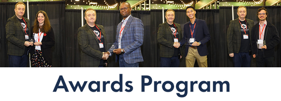
Canada’s National Geomatics Expo Awards are a great opportunity to recognize the people and organizations making a difference in the geomatics field. Whether it’s groundbreaking technology or strong leadership, these awards celebrate the achievements that are pushing the industry forward. This year, the nominees were chosen by the public, and now it’s your turn to make your voice heard. You can vote across all categories or select only the ones you’re interested in. You are limited to

A presentation on the latest advancements in construction technology. The session will begin with an introduction to key concepts such as Visual Intelligence and Reality Capture, and a quick look at how construction tech has evolved. The presentation will also include discussions on the use of Visual Intelligence and Reality Capture in construction, with real-world examples from platforms like Timescapes, Cupix, Buildots, and DroneDeploy. Attendees will learn about the challenges and solution...


Earth Observation technologies have experienced unprecedented innovation and accessibility over the past several years. The role of the commercial sector has stepped in to offer several capabilities historically only available from government. This session will focus on examples of how EO technology is being...

Reduced snowpack in the Rockies presents a severe drought risk for Southern Alberta. Mountain snowmelt in the Bow and Oldman basins maintains reservoir levels, crop irrigation, municipal and industrial supply, and ecosystem services. As climate and consumption pressures increase, accurate snow water equivalent (SWE) data is crucial for water supply forecasts, which impact allocations and emergency drought measures. Field snowpack monitoring does not provide accu...


For the built environment, digitalization is a key sustainability enabler. It helps stakeholders across the construction sector increase productivity and transparency while reducing emissions, resource consumption and costs, and adding digital tools that can help companies establish and optimize their sustainability performance.


In our rapidly evolving urban landscapes, inadequate accessibility maps leave many people with disabilities facing significant challenges. This talk begins by illustrating the problem with real examples of accessibility fails on platforms like Google Maps. Attendees are encouraged to check accessibility features on their phones, highlighting current gaps.We will then explore the necessity of specialized tools for meaningful navigation and destination planning for people with disabiliti...